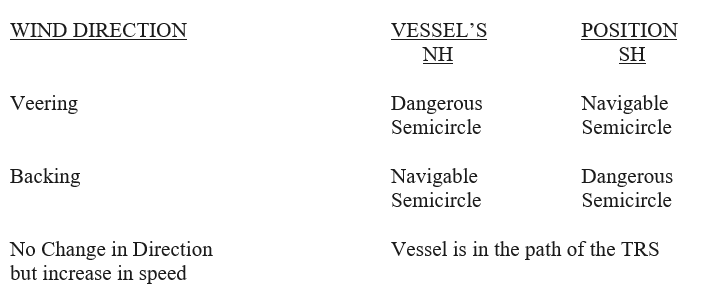
Definitions
A Tropical Cyclone is also called as a Tropical Revolving Storm (TRS).
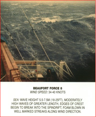
It is defined as a roughly circular atmospheric vortex, originating in the tropics or sub tropics, wherein the winds which blow in converging spiral tracks reach or exceed gale force i.e. Beaufort Force 8 (34 – 40 Knots / 62 – 74 Km / h).
The spiraling winds blow in an anticlockwise direction in the Northern Hemisphere and clockwise in the Southern Hemisphere around the TRS.
The spiraling winds blow in an anticlockwise direction in the Northern Hemisphere and clockwise in the Southern Hemisphere around the TRS.
A reduction of pressure which is large enough to be marked by a closed circulation of winds is termed a Tropical Depression. On a synoptic chart this is indicated by one or more closed isobars.
In the Tropics, as elsewhere, Depressions of varying degrees of intensity occur.
Between Mid Latitude Depressions & Tropical Cyclones
Both are atmospheric vortices in which the airflow in the lowest layers of the atmosphere follows nearly spiral tracks towards a centre of Low Pressure.
Both are associated with strong winds and low pressures.
Central pressure around 960 hPa in typical case.
TROPICAL CYCLONES
- Diameter 400 – 500 n. miles.
- Pressure gradient stronger.
- Winds are stronger.
- Increase of wind speed slow at first, then more & more rapidly to about 90 kt peak near inner margin of
- annulus(15 – 30 n. miles) from centre.
MID LATITUDE DEPRESSIONS
- Diameter 1000 – 2000 n. miles.
- Pressure gradient lesser than TRS.
- Winds are less strong than in TRS.
- Increase of wind speed gradual Almost uniform increase from speeds on the periphery to, say, 50 knots near the centre.
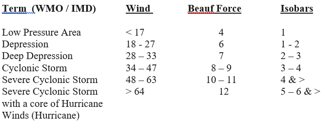
As per World Meteorological Organization (WMO) the following criteria defines precisely the various degrees of intensity of Tropical Depressions.
NOMENCLATURE & AREAS OF OCCURRENCE
a)
NORTH WEST PACIFIC OCEAN
South China Sea, Philippines,
Caroline Islands, Taiwan
Typhoon / Baguios
May – Nov
b)
NORTH EAST PACIFIC OCEAN
Coastal area from Costa Rica
to lower California
Hurricane / Cordonazo
Jun – Oct
c)
SOUTH WEST PACIFIC OCEAN
Queensland Coast
Hurricane
Dec – Apr
d)
NORTH WEST ATLANTIC OCEAN
West Indies, Gulf of Mexico,
Caribbean, Bahamas, Florida
Hurricane
Jun- Nov
e)
SOUTH WEST INDIAN OCEAN
Madagascar, African coast,
Rodriguez, Mauritius,
Mozambique Channel
CYCLONE
Dec – Apr
SOUTH EAST INDIAN OCEAN
N W Australia, Gulf of Carpentaria
WILLY- WILLY
Dec – Apr
f)
BAY OF BENGAL
A & N Islands, Indian Coast, Myanmar,
Bangladesh, Sri Lanka
CYCLONE
Apr – May & Oct – Dec
ARABIAN SEA
A & N Islands, Indian Coast, Myanmar, CYCLONE Apr – May &
Bangladesh, Sri Lanka
CYCLONE
Apr – May &- Nov
Movement of Tropical Revolving Storms
Direction of Movement
In the lower latitudes initially it moves from East to West with a small pole ward component.
It’s track is close to WNW in the Northern Hemi -sphere and WSW in the Southern Hemisphere. The storm moves at speeds of 08 – 12 knots.
The storm re-curves between 20° – 30° N or S. It’s track is N / S (in NH / SH). Its speed of further advance decreases & it may become stationery.
It then tracks NE’ly (in NH) & SE’ly (in SH) and it advances at speeds of 20 – 25 knots.
Reasons
It is lower latitudes the system is embedded in the Easterlies in the Troposphere and is steered by it. The pole ward tendency is due to variation of the Coriolis Force across its North – South extent The direct movement of the storm into higher latitudes does not take place due to the presence of the Sub Tropical Anticyclone.
In higher latitudes, there is an increase in the pole ward component as it reaches the western edge of the Sub Tropical Anticyclone.
In the mid latitudes the system is embedded in the Westerlies in the Troposphere and is steered by it.
Conditions Favourable For Formation of Tropical Revolving Storm (TRS)
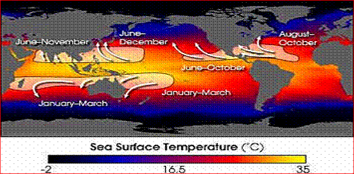
At least 2 pre-requisites are necessary for the development of TRS
A sufficiently large sea area wherein the sea surface temperature (SST) is 27° C and more (through at least 50 m depth) .
The location should be sufficiently removed from the Equator for the Coriolis Force to be effective – in practice this means that the latitude must not be less than 5° North or South ( Minimum distance of 500 kms / 300 miles from the Equator).
The role of the Coriolis Force is to provide for gradient wind balance by correcting the interaction of the pressure gradient force (the pressure difference that causes winds to blow from high to low pressure) & geostrophic winds (the force that causes winds to blow parallel to straight isobars) for centripetal acceleration (which is introduced by curved isobars).
Other pre-requisites necessary for the development of TRS are
A region of small Vertical Wind Shear in the Troposphere. A vertical wind shear of < 10 m/s (22 mph) between the surface and the tropopause is required for tropical cyclone development.
Strong wind shear can “blow” the tropical cyclone apart. The shear displaces the mid-level warm core from the surface circulation and dries out the mid-levels of the tropopause, halting the development of a storm. This means that the development must not be under the direct influence of a Sub Tropical Jet Stream.
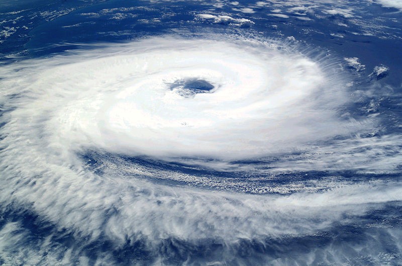
Structure Of A Tropical Revolving Storm
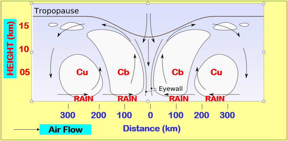
TRS typically is about 400 to 500 n. miles in diameter. It is associated with strong winds and low pressures.The average central pressure value is about 960 hPa. Pressure gradient is very steep.
The most characteristic feature of a mature hurricane is the small central region called the EYE. In the EYE region winds are light and there is little cloud.
The EYE of the system appears in the upper part of the Troposphere first and then descends.
Immediately surrounding the EYE is the EYE WALL. This EYE WALL forms an annulus, some 15 n. miles wide.
The EYE WALL contains dense mass of cloud which extends vertically from the sea surface to the Tropopause.
Outside the EYE WALL are 2 areas – inner & outer areas.The cloud is mainly continuous in the inner area while there are long spiral bands or feeders converging on the central cloud mass in the outer area.
Weather Associated with TRS
Heavy rain, sometimes with thunder & ightning, in TRS. Rain tends to occur in spiral bands in the outer region.
It becomes more intense and more widespread in the inner region,reaching a maximum in the EYE WALL.
Due to dense cloud and the effect of torrential rain the visibility reduces to very poor levels as experienced in fog conditions.
Inside the EYE the rain stops, and the Visibility improves, the clouds break and the wind falls rapidly.
Winds In A Tropical Revolving Storm
The wind increases relatively slowly at first.
Then progressively more and more rapidly to a peak of, say, 90 knots near the inner margin of an annulus which, typically, extends from about 15 to 30 n miles from the storm centre.
Within this annulus is the EYE of the storm where the wind speeds suddenly drop to below 15 knots.
Weather Over Sea In A Tropical Revolving Storm
Though the eye is by far the calmest part of the storm, with no wind at the center and typically clear skies, over the ocean it is possibly the most hazardous area.
In the eye wall, wind-driven waves are all traveling in the same direction. In the center of the eye, however, waves from all directions converge, creating erratic crests which can build on each other, creating rouge waves.
Actions to be taken in TRS
Ship Action
Bulletins issued by Met services detail not only Tropical Cyclones but also the preceding stages of Tropical Depressions and storms. Ships must collect, analyze and update this data in order to determine the best course to follow.
In addition to this forward assessment, the present conditions of weather and sea state should be observed, as these provide a cross-check on the Met bulletins. Before bulletins became available, a procedure called the Single Observer’s Action was developed as a result of seafarers’ experiences, and this procedure, which is still relevant covers the following:-
a) PROCEDURE TO ESTABLISH LOCATION OF THE VESSEL IN A TROPICAL CYCLONE
b) WARNING SIGNS OF THE PRESENCE OF A TROPICAL CYCLONE
c) EVASIVE ACTION TO BE TAKEN BY A VESSEL
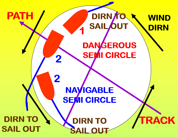
Tropical Cyclone Terminology
TRACK The route over which the a TRS has already passed
PATH The anticipated movement of the TRS
TROUGH The line of lowest barometric pressure
RIGHT HAND SEMI CIRCLE (RHSC) That half of the storm centre which lies to the RIGHT of the observer who faces along the path of the storm
LEFT HAND SEMI CIRCLE (LHSC) That half of the storm centre which lies to the LEFT of the observer who faces along the path of the storm
DANGEROUS SEMI CIRCLE The RHSC in N H and LHSC in S H
NAVIGABLE SEMI CIRCLE The LHSC in N H and RHSC in S H
DANGEROUS QUADRANT The advance quadrant of RHSC in N H and LHSC in S H .
When the existence of a TRS in the vicinity has been established , evasive action has to be taken to keep the vessel out of this quadrant.
Dangerous Semicircle
The Right hand Semi-circle (RHSC) in the Northern hemisphere & the Left Hand Semi-circle (LHSC) in the Southern hemisphere are the Dangerous Semi-circles. It is so called because:
1.A low powered ship may be blown towards the path along which the storm will pass.
2. The storm may re-curve and the storm centre may pass over the vessel.
3. The wind in the centre and the rear right quadrant of the RHSC is parallel or closely parallel to the direction of travel. The waves growing in this region experience the longest duration and fetch of the wind, thus developing the greatest heights and lengths within the storm.
4. The wind speed in the RHSC will be the sum of the cyclonic wind and the speed of the storm travel. The wind speed in the LHSC will be the difference between the cyclonic wind and the speed of the storm travel. Therefore, the wind speed in the RHSC exceeds LHSC contributing to greater wave height in this part of the storm.
5. The observed wind in this region is the sum of the cyclonic wind and the planetary wind stream parallel to the track. The wind in some parts of the RHSC in the Northern hemisphere is parallel to the direction of the main stream in which the storm is embedded. And nearly all of the winds in these semi-circles are parallel to atleast some component of the main stream.
Procedure to Establish Location of Vessel
While hove to, the bearing of the centre of the cyclone can be determined by applying Buys Ballot’s law.
If the observer has his back to the wind, then the bearing of the centre will be to the left in the N H (to the right in the S H) as follows:-
PRESSURE BELOW MEAN BEARING
05 hPa 12 Points
10 hPa 10 Points
20 hPa 08 Points
The approximate track can be established from 2 or more bearings of the centre, with interval of 2 or 3 hours between each observation.
As the changes of both wind direction and speed over a period of time are the most significant indicators of the vessel’s position, it is recommended that the vessel heaves to for a time to observe the wind.
The changes which would indicate the vessel’s position are as follows:-
Warning Signs Of The Presence Of A Tropical Cyclone
SWELL
Depending upon the extent of open ocean, an early indication of a tropical cyclone is the swell generated by the winds within the system.
These swells, generally have long wavelengths and low wave height.
They can be observed at some 600 nm from the centre.
The direction from which the swell comes is an indication of the bearing of the cyclone when the swell was generated.
SKIES
An unusually clear day may precede the appearance of Cirrus cloud with brightly coloured sunsets/sunrises.
The cloud base subsequently lowers, with the onset of showers in the outer regions of the system.
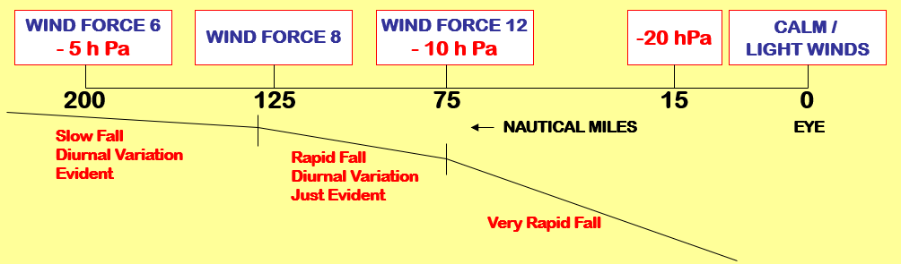
ATMOSPHERIC PRESSURE
A decrease in atmospheric pressure can indicate the presence of a tropical cyclone.
The typical diurnal variation of pressure in low latitudes is evident close to and within the area of the system.
However, this is superimposed on an overall decrease in pressure.
Warning Signs Of The Presence Of A Tropical Cyclone
Atmospheric Pressure
1. Read the Barometer. Correct the reading to standard datum (PAB: height above Mean sea level and index error.
2. Correct (1) for diurnal variation of pressure from table in pilot books or climatological atlases, taking into account latitude and local mean time.
3. Compare corrected reading (2) with mean pressure for the time of year.
If this reading is 3hPa below the mean pressure there is a possibility of a tropical cyclone.
If it is 5hPa below, then a tropical cyclone must be assumed to be present with the vessel on the outskirts of the system.
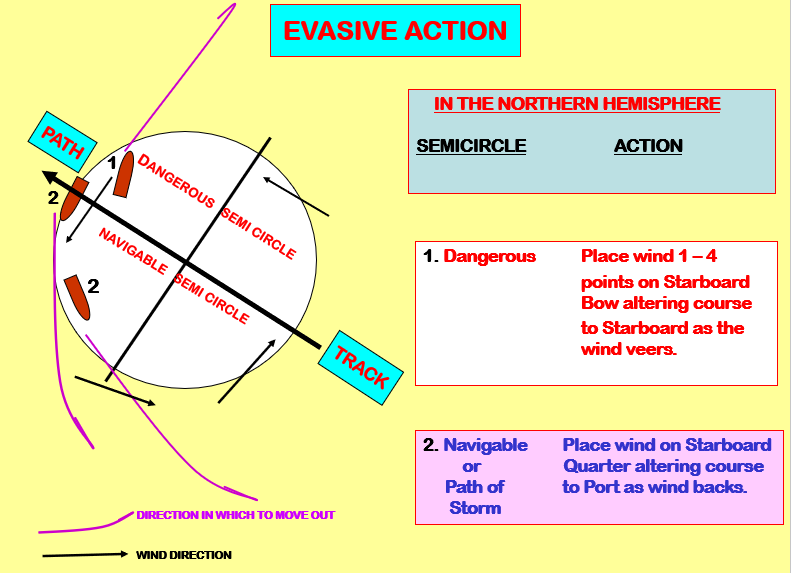
NORTHERN HEMISPHERE EVASIVE ACTION
SOUTHERN HEMISPHERE EVASIVE ACTION
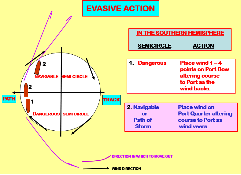
Tropical Revolving Storm TRS Evasive Actions
- While evasive action is being taken, the vessel should continue to monitor the conditions.
- These will indicate when the vessel is clear of the cyclone and the original course and speed can be resumed.
- In latitudes where re-curvature is possible, monitoring is very important, as the evasive action, taken by a vessel in the dangerous semi circle and maintained while the cyclone re-curves, may result in the vessel entering the system and possibly the eye again.
- Where insufficient sea room prevents the evasive action recommended, a vessel in the dangerous semi circle should if possible heave to with the wind on the Starboard Bow in the NH (Port Bow in the SH), thus heading away from the centre.
- In the navigable semi circle in either hemisphere, the vessel should heave to in the most comfortable position relative to wind and sea conditions.
As per SOLAS 1974 the vessel should inform the nearest coastal radio station and all other vessels in the vicinity of the storm’s existence. The vessel should also update the information at least every 3 hours while it is affected by the system.