The Global Maritime Distress and Safety System (GMDSS) is an international system relating to all vessels over 300 gross tonnes and all passenger vessels engaged on international voyages, irrespective of tonnage. It provides comprehensive communications for distress, urgency and safety operations in the terrestrial and satellite services. It specifies methods to be used to enable vessels requiring assistance to transmit specific alerting signals to indicate they require help.
There are nine vital communication functions which all vessels complying with SOLAS regulations must be able to fulfil, namely:
• Transmitting ship-to-shore distress alerts by at least two separate and independent means, each using a different radio communication service
• Transmitting and receiving ship-to-ship distress alerts
• Receiving shore-to-ship distress alerts
• Transmitting and receiving search and rescue co-ordinating communications
• Transmitting and receiving on-scene communications
• Transmission and reception of location signals
• Reception of maritime safety information
• Transmitting and receiving general radio communications to and from shore based radio systems or networks.
• Transmitting and receiving bridge to bridge communications.
One of the features of GMDSS enables watchkeeping duties to be performed by automatic means both ashore and on ships. It is unlikely that a manual radio watch will be carried out on the RT distress frequencies in any particular band, therefore it is important to precede any communications with an appropriate alert. There are four levels of priority given to such alerts:
• Distress: When the vessel or person(s) on board are in grave and imminent danger and require immediate assistance
• Urgency: When the safety of the vessel or person(s) is threatened and they require assistance. Examples include; not under command and require a tow; vessel overdue; person(s) require medical assistance
• Safety: These are reserved for meteorological and navigational warnings
• Routine: Normal alerts to attract the attention of coast stations or other ship stations
It is in the interest of safety that the watchkeepers are aware of which sea area the ship is in at any time. There are four sea areas within GMDSS. The Admiralty List of Radio Signals Volume 5 provides comprehensive details.
A1 Area
This is an area within radiotelephone range of at least one VHF coast station at which continuous DSC alerting is available, as defined by a contracting government.
A2 Area
This area excludes area A1 and is within radiotelephone range of at least one MF coast station at which continuous DSC alerting is available, as defined by a contracting government.
A3 Area
This area excludes areas A1 and A2, but is within the coverage range of the
Inmarsat satellite system, between latitudes 70º North and 70º South.
A4 Area
This area covers any sea areas not covered by areas A1, A2 and A3, ie, the polar regions.
Distress Alerting
The primary function of a distress alert is to inform a coast station and/or a Marine Rescue and Co-ordination Centre (MRCC) of the ship’s situation. On receipt of a distress alert, an MRCC will co-ordinate the rescue and will relay details to other ships in the area. If the ship is in distress, the main objective should always be to send the distress alert ashore by any appropriate means. However, personnel may also consider alerting vessels in the vicinity by sending a distress alert using Digital Selective Calling (DSC) equipment on VHF Channel 70 (for vessels within approximately 20 miles) or MF on 2187.5 kHz (for vessels within approximately 150 to 200 miles).
The distress communication procedure should always be as follows:
a) Send a distress alert on an appropriate band according to the sea area as listed below. This is a very important action as it attracts the attention of radio personnel enabling them to listen to your distress message.
b) Expect an acknowledgement from a shore station either by DSC or telephony.
c) Send a distress call and message on the Radio Telephony (RT) distress frequency in the same band as the distress alert and follow the instructions given by the MRCC/controlling station.
GMDSS Distress, Urgency and Safety Frequencies in Terrestrial Radio Bands
Sea Area Band DSC Alerting Frequency RT Communications
A1 VHF Channel 70 Channel 16
A2 MF 2,187.5 2182
A3/A4 HF* 4,207.5 4,125
A3/A4 HF* 6,312 6,215
A3/A4 HF* 8,414.5 8,291
A3/A4 HF* 12,577 12,290
A3/A4 HF* 16,804.5 16,420 (Frequencies are quoted in kHz)
* Select an HF frequency band according to the distance from the nearest HF shore station and the time of day. Generally speaking, the higher the band the greater the range. At night, a lower band will achieve greater distances. If unsure, use 8 MHz. (Inmarsat distress procedures are described later.)
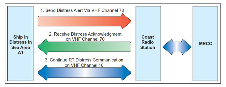
Example of Distress Transmission Procedure in Area A1
Systems To Use For Distress Alerting
| Sea Area | VHF DSC Ch.70 | MF DSC 2187.5kHz | HF DSC 4/6/8/12/16MHz | Inmarsat-C | Inmarsat-F |
| A1 | Yes | No | No | Yes | Yes |
| A2 | No | Yes | No | Yes | Yes |
| A3 | No | No | Yes | Yes | Yes |
| A4 | No | No | Yes | No | No |
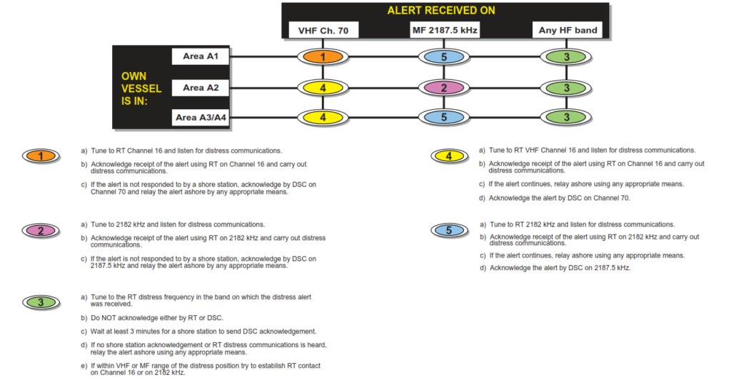
Procedure on Receiving a DSC Distress Alert
Example of distress call and message by RT:
MAYDAY, MAYDAY, MAYDAY,
This is XYZ, XYZ, XYZ, MAYDAY,
XYZ/MMSI No.
21° 34” North, 68° 15” West
On Fire
Require immediate assistance
Over
Urgency Alerts
For messages concerning the safety of the vessel or person(s) on the vessel, use the following procedure on any appropriate radio band according to the sea area:
a) Send a DSC urgency alert.
b) Send an urgency call and message.
Example procedure of how to request medical assistance from Area A3:
a) Send a DSC urgency alert on 8414.5 kHz, indicating the intended RT transmission frequency (8291 kHz) in the call. Do NOT expect to receive an acknowledgement.
b) Transmit an urgency call and message on 8291 kHz as follows:
PAN PAN, PAN PAN, PAN PAN, All stations, all stations, all stations,
This is XYZ, XYZ, XYZ
I have crew with severe injuries and require medical assistance, My position is 22° 30” North, 79° 27” West,
OVER.
Safety Alerts
If it is necessary to send a meteorological or navigational warning use the following procedure on any appropriate radio band according to the circumstances:
a) Send a DSC safety alert.
b) Send a safety call and message.
Example procedure of how to advise vessels in the vicinity of a danger to navigation and at the same time inform shore stations in Area A1:
a) Send a DSC safety alert on VHF channel 70, indicating the intended RT transmission channel in the call. Do NOT expect to receive an acknowledgement.
b) Transmit the safety call and message on VHF channel 16 (or 13).
SECURITAY, SECURITAY, SECURITAY, All stations, all stations, all stations,
This is XYZ, XYZ, XYZ
Large floating container sighted in position 30° 20” North, 64° 55” West,
Danger to navigation keep a sharp lookout, OVER.
Procedure on the Receipt of a DSC Distress Alert
See diagram above
Procedure on the Receipt of a DSC Urgency or Safety Alert
On receipt of a DSC urgency or safety alert, tune the RT to the frequency indicated in the received alert and await reception of the call and message. Do NOT attempt to acknowledge the urgency or safety alert.
Procedures for Sending Alerts via Inmarsat
Inmarsat-C Distress Alerts
Inmarsat-C is an ideal system for distress alerting and messaging. It can be used from sea areas A1/A2 and A3, but NOT area A4. Inmarsat-C does NOT support voice communications, so all messages appear as text. Inmarsat-C is a store and forward system. There are no live links between the ship and shore authorities, therefore expect a short delay before any response from ashore.
Inmarsat-C Distress Transmission Procedure
a) Send a distress alert (either designated or undesignated).
b) Expect a response from an MRCC within 2/3 minutes.
c) Compose a distress message on the Inmarsat-C editor using the following format:
MAYDAY (or SOS) XYZ/MMSI No.
18° 35” North 77° 58” West
On fire
Require immediate assistance
28 persons on board
d) Using distress priority and ideally selecting the nearest land earth station (LES) to the ship’s position, send the distress message. If an LES is not selected here it will default to the last used LES. Stand by for further communications from the MRCC.
Urgency or Safety Alerts via Inmarsat-C
If required to send urgency or safety priority messages via Inmarsat-C, compose the message using the edit facilities. Leave the message on the screen as text, then:
a) Go to ‘TRANSMIT’ mode.
b) Select routine priority.
c) Select the appropriate LES.
d) Select the special code from the following:
32 to request medical advice
38 to request medical assistance
39 to request maritime assistance
42 to provide weather danger and navigational warnings
e) Send the message as text.
GMDSS Radio Watchkeeping
At sea, the vessel shall maintain a continuous radio watch on the following:
| Frequency/Ch | Purpose of Watch |
| VHF Ch. 16 * | RT distress/urgency/safety and route call/reply |
| VHF Ch. 13 | International bridge-to-bridge safety of navigation |
| VHF Ch. 70 | Short range DSC distress/urgency/safety and routine alerts |
| MF 2187.5 kHz | Medium range DSC distress/urgency and safety alerts |
| HF 8414.5 kHz ** | Long range DSC distress/urgency and safety alerts |
| 518 kHz | Reception of NAVTEX MSI |
| Inmarsat-C | Reception of EGC MSI including shore-to-ship distress alerts |
| Inmarsat-B | Reception of shore-to-ship distress alerts |
* Vessels are required to monitor VHF channel 16 .
** Plus at least one other HF frequency from 4,207.5, 6,312, 12,577 and 16,804 kHz.
As the vessel has Inmarsat-C, there is no requirement to monitor HF DSC frequencies for A3 distress alerts. MF/HF DSC equipment can be configured to watch the 2187.5 kHz frequency only.
General Rules for Communications
All Stations are Forbidden to Carry Out
• Unnecessary communications
• The transmission of profane language
• The transmission of signals without identification
Avoid Interference
All stations are forbidden to carry out the following:
• The transmission of superfluous signals and correspondence
• The transmission of false or misleading signals
All stations shall radiate the minimum power necessary to ensure satisfactory service.
Secrecy of Communications
All administrations bind themselves to take the necessary measures to prohibit and prevent the following:
• The unauthorised interception of radio communications not intended for the general use of the public
• The divulgence of the contents, simple disclosure of the existence, publication or any use whatsoever, without authorisation, of information of any nature obtained by the interception of radio communications
Radio Log Keeping
All vessels are required to keep a radio log on the navigating bridge convenient to the radio installation. It should be available for inspection by any authorised representative of any administration.
The log contains details of the ship’s name, call sign, MMSI number, etc, details of persons qualified to operate the radio equipment and the daily diary of operation of the radio equipment. Entries in this latter part should contain the following:
• Details of communications relating to distress, urgency and safety including times and details of ships involved and their positions
• A record of important incidents such as breakdown or malfunction of equipment, adverse propagation and interference
• Serious breaches of radio procedures by other stations
• The position of the ship at least once per day
• Details of the tests carried out on radio equipment as in paragraph 5 below
Note: Any messages received as hard copies, such as NAVTEX, EGC, etc, can be appended in date order at the rear of the logbook and an indication of the time and frequency received can be noted in the log.
Testing of GMDSS Radio Equipment
DailyTests
• The proper function of the DSC facilities shall be tested at least once per day without radiation of signals, by use of the means provided by the equipment
• Battery voltage should be checked once per day and where necessary brought up to fully charged condition
Weekly Tests
• Proper operation of the MF DSC facilities shall be tested weekly by means of a test call with a coast station. When out of range of an MF coast station for longer than one week the ship should make a test call on the first opportunity when the ship comes into range of such a coast station
Note: Live tests should NOT be made on VHF DSC equipment.
Monthly Tests
• Each EPIRB shall be examined monthly by operating its test facility (if this is in line with the owners standing orders) and ensuring that it is able to float free. It should be inspected for security and any signs of damage
• Each SART should be tested by means provided and by observing rings on nearby 3cm radar
• Each survival craft VHF shall be tested on a channel other than channel 16, using a rechargeable battery not the lithium battery
• The radio battery compartment should be inspected and the security and condition of all batteries providing a source of energy for any part of the radio installation should be checked
• Printers should be checked daily to ensure an adequate supply of paper • The condition of all aerials and insulators should be checked monthly
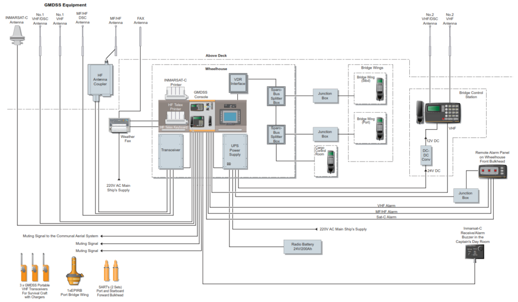
Brief Description of GMDSS Equipment
Search and Rescue Transponder (SART)
The purpose of a SART is to indicate the position of survival craft or survivors during search and rescue operations. It operates in the 3cm radar band only. When activated, a SART sweeps the 3cm radar band and on receipt of radar pulses from a search and rescue craft it transmits coded signals. This results in a series of dashes appearing on the rescue craft radar display; similar to those of a RACON. The echo nearest to the rescue craft’s own position represents the position of the SART. The minimum range of a SART is 5 nautical miles. In order to achieve this, the SART should be mounted at least 1 metre above sea level in a vertical aspect. If lying in the sea, the range may be limited to approximately 1 mile.
Emergency Position Indicating Radio Beacon (EPIRB)
An EPIRB is a secondary means of transmitting a distress alert ashore – usually from a survival craft. It can be activated manually, but may also be released automatically by a hydrostatic release mechanism if the vessel sinks. Three types of EPIRB can be used within GMDSS:
• COSPAS/SARSAT satellite EPIRB giving coverage of all sea areas
• Inmarsat-E EPIRB giving coverage in sea areas A1/A2 and A3
• VHF DSC EPIRB giving coverage in sea area A1 only
All EPIRBs must be capable of indicating the vessel’s ID and position. Vessel ID information is encoded into the EPIRB by the equipment manufacturer. Positional information can be determined automatically by the COSPAS/ SARSAT satellites from measuring the Doppler effect; by having an in-built GPS receiver or by manually inserting the position via a keypad on the EPIRB. For COSPAS/SARSAT EPIRBs, there may be a maximum of 90 minutes before the alert is received ashore.
Inmarsat-E EPIRBs provide almost instantaneous alerting.
VHF EPIRBs work on VHF channel 70 and send a designated DSC alert to coast stations and vessels within an A1 area. They have an in-built SART for determining position.
Digital Selective Calling (DSC)
DSC is an automated watchkeeping and alerting system operating in the VHF, MF and HF bands. It permits unmanned watchkeeping for distress/urgency/ safety and routine calls in the terrestrial radio service by having dedicated watchkeeping receivers listening out continuously.
| Band | Frequency/Channel | Use |
| VHF | Channel 70 | Distress/urgency/safety and routine alerts |
| MF | 2187.5 kHz | Distress/urgency/safety alerts |
| MF | 2177.0 kHz | Routine shore-to-ship alerts |
| MF | 2177.0 kHz | Routine ship-to-ship alerts |
| MF | 2189.5 kHz | Routine ship-to-shore alerts |
| HF | 4207.5; 6312; 8414.5; 12577; 16804.5 kHz | Distress/urgency and safety alerts |
| HF | 4, 6, 8, 12, 16, 18, 22 and 25 MHz bands | Paired DSC frequencies are available for routine alerts. Details in ALRS Volume 1 |
Note: Frequencies shown in red should be monitored continuously by DSC watchkeeping receivers whilst at sea. To receive routine DSC alerts in MF and HF bands an additional scanning receiver must be fitted.
Maritime Mobile Station Identity (MMSI) System
Each mobile station (ship) and shore station having DSC equipment is issued with a unique MMSI number. This number is programmed into all DSC equipment on installation. Self-identification is always automatically included in any DSC transmission. The MMSI system also permits individual stations or groups of stations to be called. The allocation of MMSI numbers is as follows:
Ships Stations
9 digits, the first three being the country MID: eg, 232123456.
Shore Stations
9 digits, the first two being 00, then country MID: eg, 002321234.
Group of Stations
9 digits, the first being a single 0, then country MID: eg, 023212345.
Reception of Maritime Safety Information (MSI)
GMDSS provides facilities for the reception of meteorological warnings, navigational warnings and shore-to-ship distress alerts. SOLAS regulations require ships to monitor the appropriate frequencies in order to receive MSI in their area.
Short Range MSI
NAVTEX – operating on the following frequencies:
• 518 kHz for English language broadcasts
• 490 kHz for second language, or supplementary broadcasts
• 4209.5 kHz in tropical zones to overcome the effects of MF static
518 kHz has to be included in a NAVTEX receiver. The other frequencies may or may not be fitted according to vessel requirements.
Long Range MSI
• Enhanced Group Call (EGC): Operating via Inmarsat-C
• HF NAVTEX: Operating in areas where MF NAVTEX and EGC are not available
Details of these systems providing worldwide coverage are to be found in Admiralty List of Radio Signals Volumes 3 and 5.
Facilities on NAVTEX and EGC receivers allow operators to programme reception of messages from different areas. EGC receivers automatically restrict the reception of messages to the NAVAREA that the vessel is in by awareness of the vessel’s position via GPS input. The world is divided up into 21 ‘NAVAREAS’, each having its own provision. Additionally, choice can be made over the type of warning available for reception. In order not to receive unwanted information, navigators should programme MSI equipment accordingly.
Types of message which can be programmed:
A: Navigational warning*
B: Meteorological warning*
C: Ice report
D: SAR info (distress alerts relays etc)*
E: Meteorological forecasts
F: Pilotage messages
G: Decca warnings
H: Loran-C warnings
I: Omega warnings
J: Satnav warnings
K: Other navaid warnings
L: Navigational warnings additional to letter A* V, W, X, Y: Special services – trial allocation
Z: No messages on hand
Note: Message types marked * cannot be disabled.
Satellite Communication Systems
Inmarsat, the International Mobile Satellite organisation provides high quality voice, telex, data and facsimile circuits to suitably equipped vessels. The system comprises of four geostationary satellites in orbit approximately
36,000kms above the equator. Each satellite provides coverage for a particular ocean region, as below. Communication, via these satellites, at latitudes greater than approximately 70° are unreliable due to the satellites being out of line-of- sight when so far north or south.
The four satellites cover the main ocean regions and are named accordingly:
• AOR-W Atlantic Ocean Region West
• POR Pacific Ocean Region
• IOR Indian Ocean Region
• AOR-E Atlantic Ocean Region East
Network Co-ordination Station (NCS)
Each ocean region has its own Network Co-ordination Station (NCS) which controls the allocation of channels to MESs and LESs within its region. When a call is initiated, the NCS connects the MES to the LES.
Land Earth Station (LES)
Within each of the satellite ocean regions there are a number of Land Earth Stations (LES). The function of the LES is to provide a connection between the Inmarsat system and national and international telecommunications systems worldwide. An LES may also be referred to as a Coast Earth Station (CES).
Mobile Earth Stations (MES)
Each vessel equipped with suitable Inmarsat equipment is known as a Mobile Earth Station (MES). Each MES is issued with a unique Inmarsat Mobile Number (IMN). If a user has more than one MES, each will have its own Inmarsat Mobile Number (IMN).