
Numerous groundings and near misses have occurred on ECDIS equipped ships that could have been avoided but for failures in the setup and use of ECDIS. Like most of the world’s merchant fleet trading internationally, your ship(s) is most likely equipped with an Electronic Chart System (ECS) or Electronic Chart Display and Information System (ECDIS). Maybe it is fully compliant with the IMO requirements for an ECDIS and therefore the primary means of navigation, or perhaps you are still transitioning towards an approved system.
The primary function of ECDIS is to enhance the safety of navigation, but experience is showing that installation and approval alone are not enough to achieve this goal. Comprehensive training, including type-specific familiarisation, and updated Safety Management System (SMS) procedures are essential to ensure safe ECDIS use without introducing new risk.
Furthermore, Port State Control Authorities have reported an increase in deficiencies concerning ECDIS use following Concentrated Inspection Campaigns (CIC) on safe navigation. The age of e-Navigation is firmly upon us and the transition to electronic-based navigation is a fundamental shift away from the not-so-distant past where azimuth sights, sextants, and parallel rulers were the indispensable tools of every navigator.
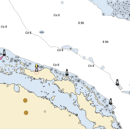
A base ENC with limited chart information compared to the unfiltered chart of the same channel and location. Overuse or improper use of filters and contours may result in ambiguous displays of soundings and potentially dangerous interpretations.
Risk Factors
Everything a ship’s officer can do on a paper chart must be feasible on an ECDIS device; i.e. a functional equivalent. This includes the most basic of navigation tasks such as manually plotting the ship’s position by range and bearing; thorough passage planning, including voyage notes and callouts; marking of nogo areas; applying manual chart corrections … and so on. The reality is, ECDIS can do all this and a whole lot more.
Modern ECDIS systems are now so functional that inadvertent actions or settings may be applied, which can then go unnoticed. Safety contour and safety depth functions, for instance, may be misused rendering the alarm meaningless. Display settings may reduce the visibility of essential information from the screen as previously shown.
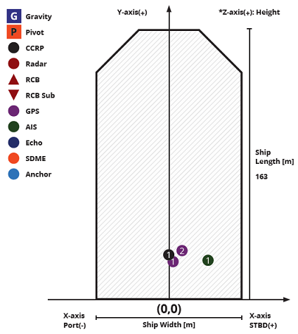
Position data and/or reference points may have unwanted offsets – for instance, when was the last time the CCRP (Consistent Common Reference Point) settings were checked? Are they correct for multiple antennas and radar systems? Are the CCRP settings locked and password protected against accidental meddling?
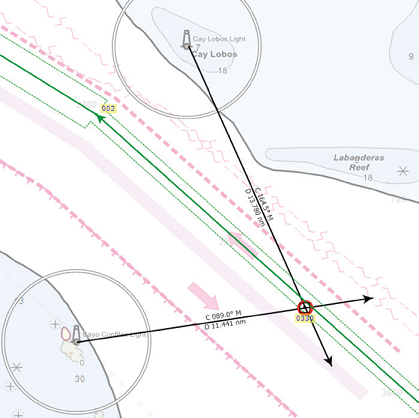
Manual position plotting can be done quickly and easily on an ECDIS, but it is critical that officers familiarise and regularly practise this function.GPS positions should be cross-referenced using visual/ radar range and bearings.
Safety contour and safety depth settings can drastically affect the display and when alarms are given.
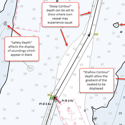
The Safety Contour Depth should normally be set to the “Vessel Safety Draft,” which is commonly calculated as:
Vessel Safety Draft = Vessel Draft + Dynamic Squat + Safety Margin.
The Safety Contour marks the boundary between “safe-water” and shallow water and can be set to give an alarm if the ship is approaching the contour.
Consistent Common Reference Point settings and locations of antennas, radars and other reference points should be set correctly and frequently checked.
These are just a few of the unwelcome risks that may be introduced unintentionally if navigators are not properly trained and instructed in the correct use of the systems fitted aboard their ships.
Common operational mistakes
When properly operated, ECDIS is an exceptional tool that drastically improves situational awareness and operational efficiency, and can reduce errors. On the other hand, over-reliance or lack of familiarity can lead to calamitous consequences.
The term “ECDIS assisted Grounding” has not arisen from nowhere, and based on our experience, recurrent themes often include the following:
Improper use of charts: i.e. not using or having the necessary charts for the intended voyage or not applying chart updates frequently and correctly
Not following or being aware of the manufacturer’s software maintenance updates and not updating the ECDIS to be compatible with the latest version of the IHO Standards.
Improper use of safety settings and built-in safeguards such as route checking and safety alarms related to depths.
Improper display settings, filters and scale.
Not using the route checking function at all or not using it with an appropriate Cross Track Distance (XTD). Not visually checking the route at an appropriate scale.
Lack of familiarity with the specific ECDIS type onboard.
Over-reliance on ECDIS and the displayed GPS position.
Inability to use or lack of familiarity with manual position fixing functions such as range and bearings.
Handover between deck officers including ECDIS-related information.
When Cross Track Distances are properly set to each leg of a voyage plan then route checking assists in checking for potential obstructions, dangers and insufficient depths.
When fitted, ECDIS must be type approved, conform to the relevant IMO performance standards, connect to an emergency source of electrical power, and have at least gyrocompass, speed log and GPS receiver inputs.
The system must have up-to-date Electronic Nautical Charts (ENC), or Raster Navigation Charts (RNC) where ENCs are not available or of an appropriate scale.
All nautical charts for the intended voyage(s) must be installed and maintained to be compatible with the latest applicable International Hydrographic Organization (IHO) chart content and display standards. Backup arrangements must be available, which can be either a secondary type-approved ECDIS or official, up-to-date paper charts.
Beyond the aforesaid general requirements of a SOLAS-compliant ECDIS, shipowners and operators are encouraged to undertake regular risk assessments of ECDIS navigation, including potential over-reliance of the system and improper use of the safety settings.