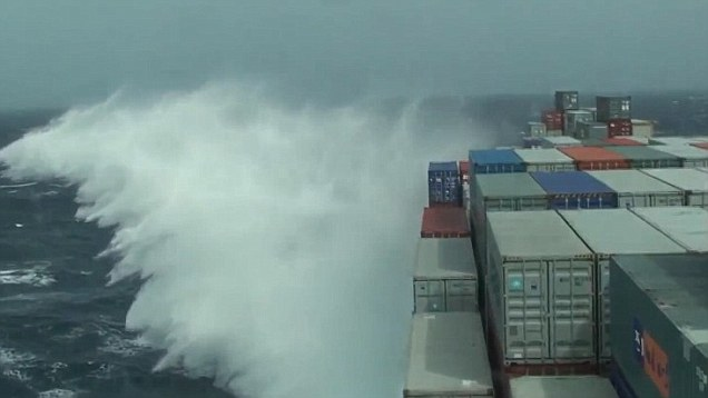
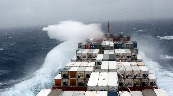
Efficient weather service to shipping depends on the timely location and accurate tracking of weather systems over the open sea, which covers three-quarters of the surface of the earth. Weather is a very important factor in determination of the passage and safe completion.
Need for weather reporting systems
Overland, it is easily possible to establish weather observation stations (observatories) but over the seas, the establishment of ocean weather ships is a very major operation involving very great capital and recurring expense. Because of this, it is necessary for merchant ships, on the high seas, to spend a few minutes per day in sending out reports of the weather experienced. Even if the weather is normal, a report to that effect is very important.
Reporting system
As recommended by the World Meteorological Organisation (WMO), each government recruits a number of merchant ships called the Voluntary Observing Fleet (VOF).
The Indian VOF consists of Indian ships and such foreign vessels that frequently and regularly call at Indian ports and hence treat an Indian port as their homeport.
Each vessel of the VOF makes weather observations at fixed Greenwich Mean Times (called synoptic hours), codes these observations and transmits them by W/T, TOR (Telex over radio), or by Satcom (Satellite communication), as soon as possible, to the area headquarters or to the nearest coast radio station. The coast radio stations transmit these coded messages by land telegraph or teleprinter to the area headquarters, on a priority basis. The ship does not incur any expense for this transmission. The respective meteorological departments and the administration bear these charges. The India Meteorological Department provides all necessary equipment, publications and stationery used by the Indian VOF.
The weather codes have been devised in such a manner that the messages can easily be electronically processed and stored to enable better forecasts to be made.
The area headquarters gathers all the reports of that area and makes weather forecasts, which are transmitted to ships of that area, as W/T weather bulletins , through selected coast stations, at fixed times.
Times of observations
Under normal conditions of weather, the hours of observation, called synoptic hours, are 00, 06, 12 and 18 GMT. In cases where there is disturbed weather, additional synoptic hours are 03, 09, 15 and 21 GMT.
The coded messages should be transmitted as soon as possible. In case of any genuine delays, a message may be transmitted up to four hours after the time of observation. In the case of ships. the time of observation is always the GMT when the barometer reading is taken.
In case any unusual but urgent weather phenomena are seen, a special message in code or in plain language may be sent out at any time. Such messages, if sent out in plain language, carry the prefix TTT. Examples of such messages are given later in this module.
In rare cases, as during a TRS, the area headquarters may request a ship in a particular area for special observations. The master should regard such observations as urgent and the messages should be sent out even if it necessitates the calling of a radio officer to duty, during his off duty hours.
Meteorological log books
Each ship of the VOF is given a meteorological or weather logbook. All weather observations at synoptic hours and any special message must be recorded neatly and legibly in the weather logbook, whether they were transmitted by W/T or not.
When each logbook is completed, it is to be returned to the India Meteorological Department. The W/T messages received from the vessel will be compared with the logbook to eliminate errors during transmission. The log- book may contain additional remarks that were not transmitted in the coded messages. The data from logbooks are fed into computers for future use.
Classification of ships
In accordance with the recommendation of the WMO, vessels of the VOF are divided into three categories:
Selected ship: A mobile ship which is equipped with sufficient certified meteorological instruments for making observations and which transmits the required observations in the full code consisting of eighteen to twenty one groups.
Supplementary ship: A mobile ship which is equipped with a limited number of certified meteorological instruments for making observations and which transmits the observations in the abbreviated form of the code consisting of twelve or more groups.
Auxiliary ship: A mobile ship normally not provided with certified meteorological instruments which transmits weather reports in disturbed weather or under a special request, in the reduced form of the code consisting of eleven or more groups or in plain language.
Ships not recruited in any of the categories are requested to transmit weather reports on their own initiative in case of disturbed weather.
Equipment supplied by IMD
The following equipment is manufactured and supplied, free of charge, by the India Meteorological Department:-
Navigation
Selected ship:
- Kew-pattern mercury barometer with Gold Slide
- Weekly barograph
- Whirling psychrometer
- Sea-thermometer
- Marine bucket
Supplementary ship:
- Kew-pattern mercury barometer with Gold Slide
- Whirling psychrometer
Publications supplied by IMD
The India Meteorological Department, supplies the following publications to selected and supplementary ships, free of charge:
- Monthly meteorological charts of the Indian Ocean
- Indian Ocean Currents.
- Marine Observer’s Handbook.
- International Cloud Atlas.
- Ship’s Weather Code.
- Weather Services to Shipping, Fishing Vessels and Marine Interests.
- Code of Storm Warning Signals.
- Handbook of Cyclonic Storms in the Bay of Bengal.
- Winds, Weather and Currents Coasts of India.
- State of Sea Card.
Meteorological services as per SOLAS 1974
Regulation 4 of Chapter V of the International Convention for the Safety of Life at Sea (SOLAS) 1974 specifies the action of the Governments with respect to the meteorological services. The following is the gist of it. You may like to read the same.
V / 4 specifies the following duties for the Administrators with respect to the weather services.
- Encourage collection of meteorological data by ships at sea.
- Arrange for their examination dissemination and exchange in a suitable manner.
- Providing for use of instruments of high accuracy and checking the same.
- Arrange for the following services:
- Warn ships of gales, storms and tropical revolving storms by issue of rad, warnings and local signals.
- Issue of daily weather bulletins for shipping, containing data on existing weather, waves, ice and forecast. The bulletins should contain information so that the ship can prepare a weather chart.
- Transmission of facsimile weather charts,
- Provide the necessary weather information publication to facilitate weather observations.
- Provide daily weather charts for departing ships,
- Provide tested equipment to selected ships such as barometer, barograph. psychrometer and a suitable apparatus for measuring sea temp.
- Encourage selected ships at sea to take and report observations at least four times in a day. Encourage other ships to take observations in a modified form in areas where shipping is sparse and / or the weather is unsettled.
- Provide facilities to send such report by radio with no cast to the ships
- Instruct ships to send their messages through ocean weather ships or other ships when it is not possible to send them by radio.
- Instruct masters to report in accordance with the international radio regulations (with a prefix TTT) when:
- wind speed exceeds 50 knots
- the ships meets dangerous ice,
- the ship meets dangerous derelicts
Examples of safety messages
Note: GMT 160830 means 16th day 08 hours 30 minutes.
- TTT Ice. Large berg sighted in 4605n 4410W at 150800 GMT.
- TTT Storm. 180030 GMT. 2004N 11354E Barometer corrected 994 millibars. tendency down 6 millibars. Wind NW force 9 heavy squalls. Heavy easterly swell. Course 067, 5 knots.
- TTT experiencing severe icing 021400 GMT. 69N 10W. Air temperature minus 2. Wind NE force 8.
Weather bulletins
Details of weather bulletins sent out in each area – call signs of stations, radio frequencies and timings – are given in the Admiralty List of Radio Signals Volume 3.
In accordance with IMO and WMO recommendations, a weather bulletin used to consist of five parts sent in the Morse code. With the establishment of the GMDSS these messages are now being transmitted in plain language.
Part I Storm warning in plain language.
Part II Synopsis of weather conditions in the forecast area, in plain language.
Part III Forecast in plain language.
Part IV Surface weather analysis synoptic chart in the International Analysis Code (Fleet).
Part V Data of surface observations from ships and selected land stations and upper-air reports, all in WMO codes.