
Ice is found at high latitudes in both hemispheres i.e. Northern Hemisphere (Artic) and Southern Hemisphere (Antarctic) regions. They differ greatly because of their physical dissimilarities. The Artic Basin is an area of ocean, which is covered up a thin shell of ice about 3.5 mtr thick.
The Antarctica about the same area is covered by an ice cap, which is upto 3000 mtrs thick. The annual mean temperature at South Pole is -49°C. (lowest, recorded —88.3°C) where as at the North Pole the annual mean temperature is – 20°C (lowest recorded -50°C).
The ice cap covering the Antarctic continent accounts for more than 90% of the earth’s permanent ice. This ice cap is constantly moving outwards towards the coats where many thousands of icebergs are calved each year from the glaciers and ice shelves which reach out over the sea.
ICE CLASSIFICATION:
Ice at sea is rnainly of three kinds
- Sea Ice is formed by the freezing of sea water. It is a complex substance varying in shape, size, age, thickness and many other characteristics. It does not harm any life masses or properly.
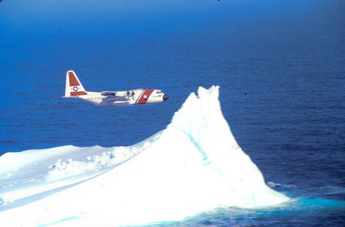
- Icebergs are huge masses of floating ice. They can be serious hazards to the navigation. However, they are present in limited areas around the oceans. In mid 1912, a passenger vessel ‘TITANIC’ on her maiden voyage from Southampton to New York collided with the iceberg about 300 m. South East of New found land and sank within three hours.
- River ice is derived from fresh water and is sometimes encounter in harbours and off shore areas close to estuaries during spring break up
FORMATION OF ICE (SEA ICE):
Fresh water and salt water do not freeze in the same manner. This is due to the presence of dissolved salts in the Sea water. In shallow waters, the convection currents have hardly any vertical distance to travel. The entire body of water is easily cooled to freezing temperature, and sea ice forms over shoal banks, over bays, straits, where there is no appreciable current or tide and where the salinity is low. When the air temperature, is very low and a few particles of ice are already present. These particles can cause more ice to form on the surface. However the waves in the sea obstruct the formation of Sea ice. If Sea-ice is already formed wave action breaks it up into small pieces called “Brash Ice”.
Currents or tides carry away the ice. Particles and retard the growth of Sea ice. The growth is slow because the surface ice insulates the water from the cold air. In shallow waters, the convection currents have hardly any vertical distance to travel. The entire body of water is easily cooled to freezing temperature, and sea ice loses over shoal banks, over bays, straits, where there is no appreciable current or tide and where the salinity is low. When the air temperature is very low and a few particles of ice are already present. These particles can cause more ice to form on the surface. Currents or tides carry away the ice particles and retard the growth of Sea ice. The growth is slow because the surface ice insulates the water from the cold air.
ICEBERGS:
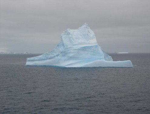
They are huge masses of floating ice, broken off from the obstructions like rocks. trees or mountains side and freezes into ice. It is called “Glaciers’. When the lower edge of a glacier reaches the sea, large chunks (few miles across) break off and are carried away as icebergs, by ocean currents and winds.
Icebergs of glacier origin have irregular shapes. Their tops are frequently pinnacle shaped and their sides sloping. They are not a good Radar targets. They are about 5 times its visible height above the sea surface.
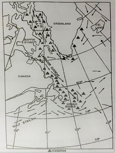
East Greenland current carries the icebergs born on the east coast of Greenland Southwestwards. After rounding the Southern tip of Greenland, they join the icebergs born on Greenland West Coast. They are then carried northwards by the West greenland current as far as about 75 N and then brought southwards by the is Labrador Current and finally reaches the Grand Banks.
They are 1/2 year old. The tallest iceberg seen in the grand banks was 80 mts. high and 520 rnts long. Icebergs over 1000 mts can also been seen further North. Volume of these icebergs is about 20,000 m2. Rate of drift is rather erratic and is about 10 & 70 NM per day.
Parts of the icebergs may extend horizontally much further underwater than visible above water. The International Ice Petrol advises shiprnasters to keep at least 100 Miles off from the last reported portion of an iceberg.
Destruction of icebergs was considered, by the International Ice Petrol, but proved uneconomical. Towing of icebergs to the ports to supplement Fresh water supplies was also considered but due to increase in temperature near shore, the iceberg May reduce to size of an ice-cube by the time the tow reaches the port. Strong wind and waves may also reduce icebergs.
‘Visibility of an Iceberg” during daytime in clear weather is about 12 to 15 rniles off from the bridge. On cloudy day it reduces to 10 to 13 miles. In restricted visibility it can reduce to 2 to 3 miles. At night time with clear skies and good visibility about 1/4m to 1 mile. One cannot detect in moderate to rough seas.
Probable Indication of the proximity of ice:
- It is possible to detect iceberg by Radar. However smooth. sloping sides of the iceberg makes them poor radar targets. In addition, sub refraction usually exists in the vicinity of icebergs.
- Thunderous noises can be heard as growlers from icebergs.
- A whitish glare on low clouds near horizon and its blink.
- Presence of small pieces of ice, which may have calved from the iceberg, on the leeward side of the Iceberg.
- Noise of the seas breaking over edge of the iceberg.
- A sudden drop of wind speed accompanied by a drop of air temperature.
- Echoes of the ships whistle from the iceberg (though not reliable).
Icebergs Classification
| Type | Ht Above sea level in m | Length in m |
| Growler | Under 6 | Under 1 |
| Bergy Bit | 1 to 6 | 6 to 15 |
| Small Berg | 6 to 15 | 15 to 60 |
| Medium Berg | 15 to 45 | 60 to 120 |
| Large Berg | 45 to 80 | 120 to 215 |
| Very Large Berg | Over 80 | Over 215 |
Approximate Ice limits: –
- Off the Coast of New found land, the easterly limit is 40°W and Southerly limit is 40° N.
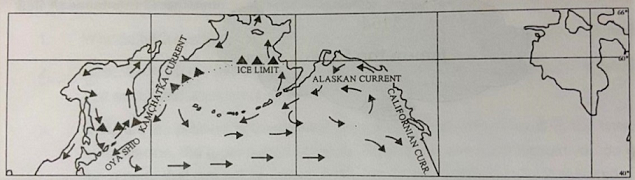
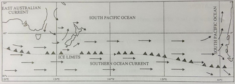
- In the North Pacific, line drawn from the NE tip to Japan, passing just worth of Aleutian Islands, to approx. 60° N — 160° W. In the Southern Hemisphere, roughly the parallel of 50°S, except in longitude 20°W, where it is 40° S. (Cape Tasmania, & New Zealand are clear of the ice limit).
These are shown in fig along with Ocean currents.
International Ice Patrol:
After the Incidence of “TITANIC’ tragedy, the maritime nations. using the North Atlantic sea routes, got together and set up the International Ice Petrol (IIP) in 1915. Its Headquarters are now shifted at New York and is under the direction of the U.S coast guard. Its prime object is to warn ships of the extent and limits of icebergs and sea ice in the North Atlantic. Service operates during the ice season from late February or early March to about end June.
Masters duty regarding Ice:
According to Chapter V of SOLAS 1974, rnaster of every vessel, on receiving report of ice on or near his track is to proceed at a moderate speed at night or to alter course to pass well clear of the danger zone. He is also required to make the following reports:
- Type of ice;
- position of the ice/ship
- UT (GMT) and date of observation.
- On encountering air temperature below freezing temperature with gale force winds causing severe ice accumulation on ships,
- Air and Sea temperatures, force and direction of the wind position of the ship;
Ice Accumulation on the ship:
In certain condition ice, formed of fresh water or seawater, accumulates on the hulls and super structures of ships. This can be a serious danger. Ice accumulation may occur from three causes: –
1. Fog, formed by evaporation from the relatively warm sea surface, combined with freezing conditions.
2. Freezing drizzle, rain or wet snow:
3. Spray or sea water breaking over the ship when the air temperature is below the freezing point on sea water (About -2°C)
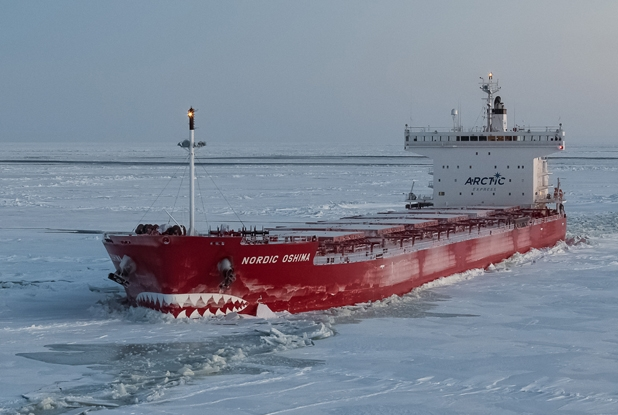
Ice Breakers Assistance-
Ice Breakers are available for the assistance of vessels in Ice, bound area. Masters of icebreakers are highly skilled and experienced in the specialist field of ice navigation, ice breaking and ice escorting.