ENCs are updated by weekly ‘Notices to Mariners’ issued by Hydrographic Offices / Regional ENC co-ordination centers ( RENC) and corrections are received on the vessel either by email or data file (AVCS DVD). The actual updating is either applied to the ECDIS chart database automatically or by the user. The ECDIS generates error message when the update is unsuccessful or when a ENC is in use and has not been corrected up to date.
All masters and navigating officers must be fully aware of how to update and maintain the on board ECDIS. It must not be left for the designated navigating officer to have sole knowledge on the updating procedure and process. Updating principles should be covered under ECDIS generic training but, more importantly, also under the type specific training as different ECDIS models vary in their updating process.
Upon receipt of the ECDIS updates, the Navigating Officer must ensure that the corrections are applied to all ECDIS units fitted on board and verified by the Master.
On ships fitted with two ECDIS, both ECDIS should not be kept synchronized with each-other ( Master and Slave) and should be kept independently. The received correction should be applied on back-up ECDIS first. After an interval of 8 hours and conformance that the corrections are correctly showing on back-up ECDIS, the correction is to be applied on the main ECDIS This sequence is to ensure that both ECDIS does not fail at the same time due to any bug in the correction file
Updates to ENCs are sequential, and the sequence is unique to each ENC. During the updating process ECDIS always checks that all updates in the sequence have been applied. If an update is missing then the ECDIS will indicate this; it is not possible to load later updates until the missing update is applied. The chart system operation’s manual will provide instructions on how to carry out this task.
The ECDIS maintains a list of updates applied and the date of application. This list can be used to check the update status of the ENCs loaded. Port State Control officers may use the ECDIS listing to ensure that ENCs are being kept up to date in accordance with SOLAS chapter V Regulation 27.
AVCS DVDs are sent to vessels from a company approved recognized electronic chart suppliers. However, if it gets delayed due to vessel’s schedule, vessels should directly request weekly correction from UKHO through e-mail. Vessels are provided with approved electronic means, e.g. e-Navigator, Safnav etc. which can be used to assist in management of ENCs on board.
If due to some reason, the updates cannot be received from UKHO by email, vessel must request chart agent immediately to send updated through e-mail.
After updating ENC, modification to the passage plan may be necessary to accommodate new chart features such as reporting schemes, traffic separation schemes, isolated dangers etc. A route check shall be carried out to ensure that any new dangers, which may have been added don’t present a risk to the safety of navigation.
Notices to Mariners (NTM): Much of the information in NTM is only for use on paper charts and is not applicable to ENCs or RNCs. However, vessels navigating solely on ECDIS are still required to carry latest NTM (paper copy or digital) to obtain information such as ‘Radio Navigational Warnings’, ‘Amendments to Admiralty Sailing Directions / Admiralty List of Lights and Fog Signals / Admiralty List of Radio Signals’.
All paper charts on board whether being used as back-up means for single ECDIS ships or as required for dual ECDIS ships must be kept updated to the latest Notices to Mariners onboard.
Temporary & Preliminary Notices (T&P):
Caution must be exercised when navigating solely with ECDIS as some ENC or RNC data may not take account of temporary or preliminary notices.
Temporary and preliminary notices are not handled consistently by all ENC producers at present. Some producers, like the United Kingdom Hydrographic Office (UKHO), incorporate the T&P notices into the ENCs and their updates, whilst others ignore T& Ps completely. The Navigating Officer must check the ECDIS charts to verify whether T& P corrections have been included in the weekly updates.
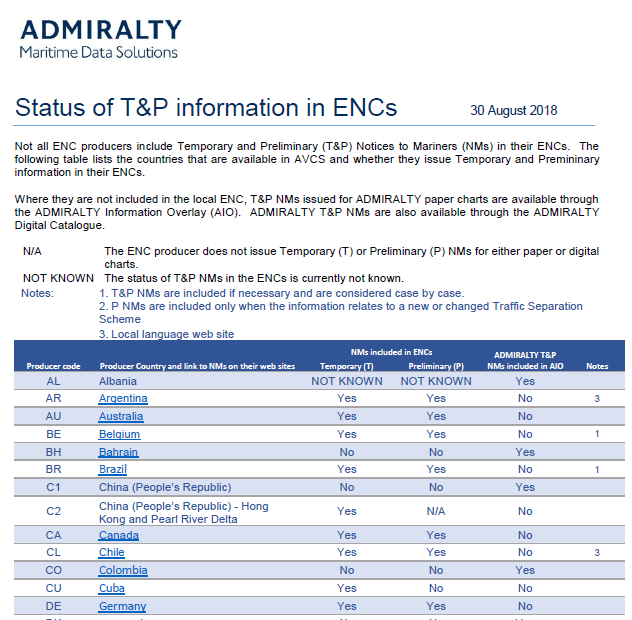
The UKHO use ‘Admiralty Information Overlay (AIO) to incorporate T&P notices within its ENCs. This tool allows the notices to be displayed as an overlay to the ENC in the Admiralty Vector Chart Service (AVCS), thus assisting the navigator in readily identifying the location and content of a notice during passage planning and the voyage itself.
Some of the ENC producers facilitate inclusion of T&P corrections within ENC.
List of ENC producers those allows such inclusion and those who do not, is available in the information folder of the Base DVD.
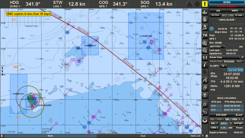
If it is included, AIO will no longer display the T&P information on ENCs .
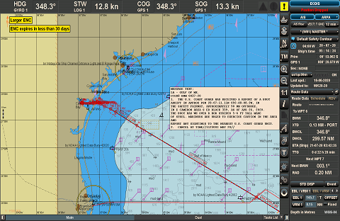
If it is not included, the T&P information will continue to display as polygons (as shown on above) on the ENC and must be plotted manually using the manual Updates.
When using charts produced by other sources, notices may be absent. These must be inserted manually as ‘Mariners Objects’ using ‘Marine Information Overlay (MIO) tool. Where ECDIS is unable to display a list of manual update applied, the navigating officer should maintain a record of all the manual updates presently applied on ECDIS in “Manual Update Correction Log”.
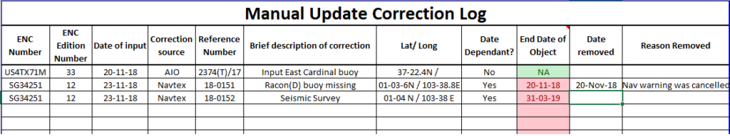
The Navigating Officer must monitor T&P notices closely so that once they are withdrawn they are also removed from the ECDIS charts on board and this list should be kept updated.
Navarea, Navtex and locally broadcasted Warnings:
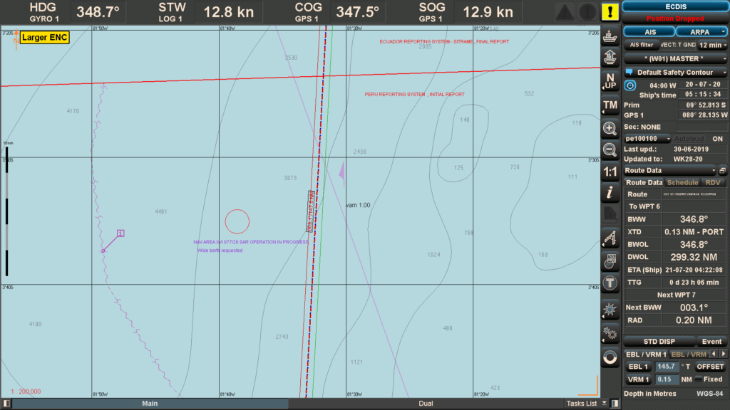
Navigational warnings transmitted by satellite and Navtex receiver are by nature more short term and urgent than T&P notices. Such notices shall be immediately plotted on ENCs using ‘Marine Information Overlay’ (MIO) facility, where provided. NAVTEX warnings may be displayed automatically if the NAVTEX is integrated into the ECDIS system.
(A) SOURCES & MANAGEMENT IN ECDIS:
1. NAV AREA WARNING:
a. Weekly notices to mariners (Section 3) – Weekly NTM published by UKHO contains Nav warning for Nav area-1.
b. SAT-C EGC : As per vessel’s route , OOW should select Nav areas in SAT-C and receive printout of all the warnings currently in force. List of warnings currently in force is received through SAT-C on weekly basis. Alternatively, OOW may request Nav area coordinator and receive all the in force warning through e-mail for nav area relevant to the passage.
These warnings have to be plotted on ECDIS using manual update.
2. NAVTEX warning:
NAVTEX warnings are local nav warnings received through Navtex transceiver. Once vessel is within coverage of selected station, Navtex receiver will start printing all the warnings for that particular area covered by that NAVTEX station. Hence, these corrections will be received and applied on ECDIS during the voyage.
If NAVTEX is not integrated with ECDIS, these warnings will have to be plotted on ECDIS using manual update similar to Nav area warnings.
However, if NAVTEX is integrated with ECDIS, these warnings will automatically appear on ECDIS display.
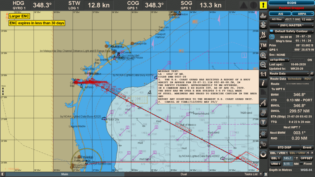
Depending upon source of warning, some warnings will be automatically plotted on ECDIS display with specific detail mentioned in it. O.O.W. will need to match the co-ordinates of automatic plot on display with the specific details of warning provided. If there is any error in position or the format of position is found incorrect, the warning plotted on display will be wrong. In such case, this will have to be corrected using manual update.
Some warnings will not be automatically plotted, but, only give an indication such as “N” or “ Navtex Warning no.” at warning location on display. OOW will need to click the warning to see the detail and plot it as a manual update. Hence, all navtex warnings, whether automatically plotted on ENC or not, must be checked by OOW.
(B) DISTANCE CRITERIA:
Minimum distance from route within which nav area/ Navtex warnings must be plotted on ECDIS having seamless charts ( without boundary) :
- Preferably all nav –warnings affecting the area of 15 miles on either side of the vessel’s track must be plotted on the ENC and recorded in the passage plan. May vary from company to company.
- Preferably all Nav-Warnings affecting the area from 15-60 miles on either side of the vessel’s track need not be plotted but must be recorded in a section of the Passage plan. However, warnings such as firing practice zone or dangers of similar nature are recommended to be plotted.May vary from company to company.
(C) LOG KEEPING FOR NAV WARNINGS / NAVTEX WARNINGS:
- Similar to management on paper charts, OOW should check all the warning printouts from SAT-C, NAVTEX, etc. If the warning is relevant to the passage and plotted / noted, the ENC no. should be mentioned on the printout and kept for record with OOW’s signature till conclusion of passage.
- Every time, vessel receives a new voyage order, OOW should check all the warnings currently in force for the passage, plot all the relevant ones as per company’s distance criteria, and delete the remaining if any on that ENC.
Chart Correction Log (NP 133C):
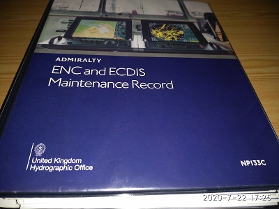
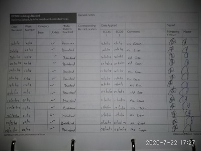
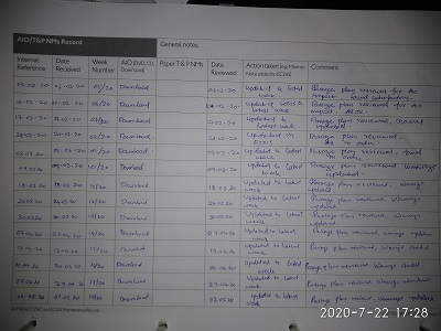
Vessels are required to maintain the ADMIRALTY ENC Maintenance Record (NP 133C). This log is designed by UKHO to streamline the management of paper records of ENC and ECDIS maintenance and make information on official digital charts more accessible for bridge team.
It is similar to the Paper Chart Maintenance Record (NP 133A), which is also produced by UKHO.
The ADMIRALTY ENC Maintenance Record aids inspections, assists SOLAS chapter V carriage compliance and streamlines information management. It is laid out in nine logical sections, with clear templates for bridge team to utilize, in order to make administrative processes faster and more efficient.
Also, by consolidating records into one well-organized folder, it enables inspectors and auditors to quickly see that ENCs and ECDIS are well managed.
The nine sections are:
- Digital Chart Service Certificate
- Schedule A
- ENC Status
4. Temporary and Preliminary Notices to Mariners and ADMIRALTY Information Overlay status
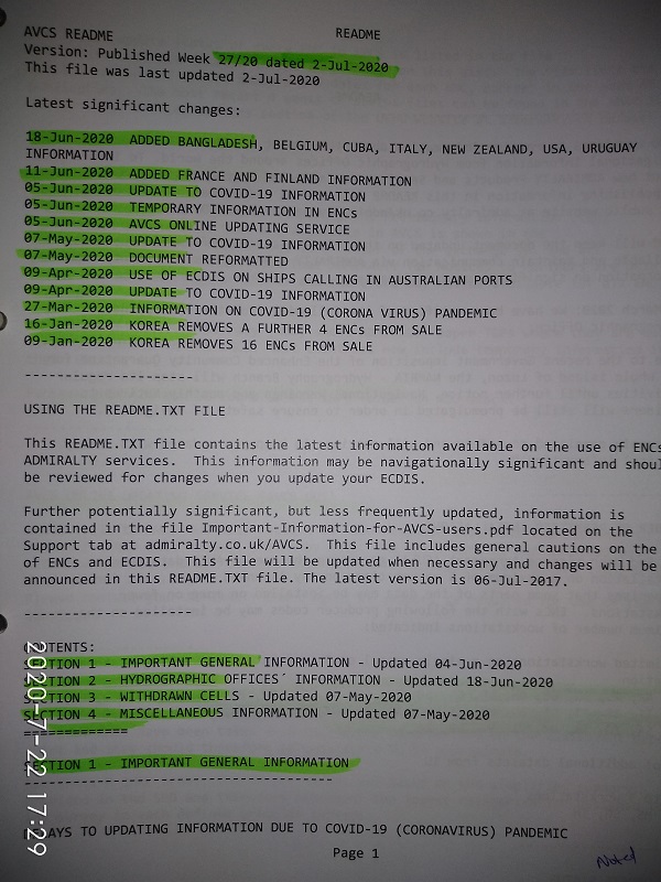
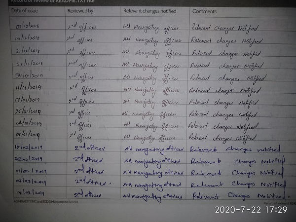
5. Important Service Notices (e.g. the README file)
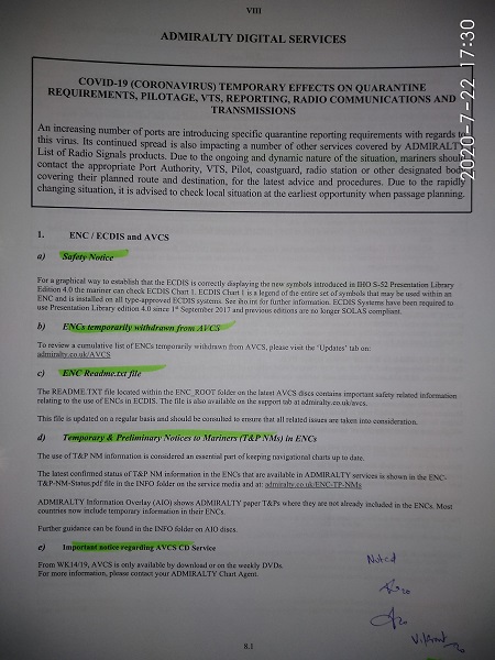
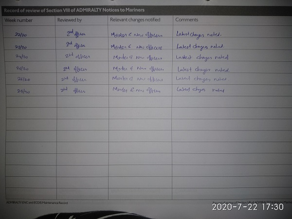
6. Section VIII of ADMIRALTY NMs
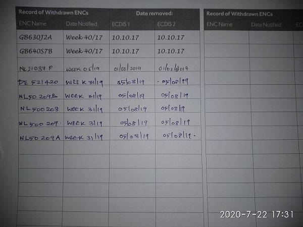
7. Cancelled and Withdrawn ENCs
8. Maintenance of ECDIS
9. ECDIS Installation
The folder sections encourage the bridge O.O.W. to store additional material on general ECDIS maintenance. If all sections are completed and kept up-to-date, the folder can be used as part of the handover process.