Browse By

Tag Archives: SHALLOW CONTOUR

ECDIS – Contour Settings

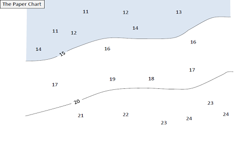
Traditional method of passage planning on paper chart: Using a draft of 14 mtr and applying a 2 mtr safety margin, the second mate would mark off areas with depth 16 mtrs and less, on the navigational chart. These areas would then be highlighted, using

Safety Depth & Safety Contour In ECDIS

Use of the Safety Depth and the Safety Contour in ECDIS Safety Depth: Value set by the mariner that is used by ECDIS to portray soundings as black if they are equal to or shoaler than the value and gray if they are deeper. Safety Contour

ECDIS

General ECDIS allows for monitoring of a ship’s position in real-time throughout the voyage and integrates information from GPS, Gyro, Radar, ARPA, AIS and other navigational equipments into a single display. It has several advantages over paper charts as listed below; Continuous route monitoring Continuous

ECDIS Contour Setting depth

Safety Contour = Dynamic draft + Minimum Net UKC requirement – Height of tide Shallow Contour = One Contour less than Safety Contour 1. Why Height of Tide is being subtracted from the Safety Contour depth?   Why it is not added, as we do for