Plotting of manoeuvres
These examples assume no delay between the time of the last plot and the completion of any planned manoeuvre. In practice there will be a time delay in taking bearing, plotting etc, which should be accounted for by projecting the last plotted position (A) by the time interval required.
Objective
To find the new CPA by alteration of course by a predetermined amount. The course to be altered is an estimated one and should be a large alteration to make it effective.

- Make Basic radar plot (OAW triangle)
- Determine the amount you are going to alter your course.
- WO represents the course you are presently steering. Let us assume you are going to alter 30° to starboard. Draw a line from W to represent the new course (30 ° to Stbd).
- With a divider/compasses measure WO and draw an arc cutting the new line at O₁ (since there is no change in own vessel’s speed).
- This is your new course line (W0₁).
- From O₁ draw a line through A and well past the centre.
- Make a new CPA (CN₁) by dropping a perpendicular from the centre onto the O₁A line.
- Measure new CPA. (CN₁) and the time taken to reach this point.
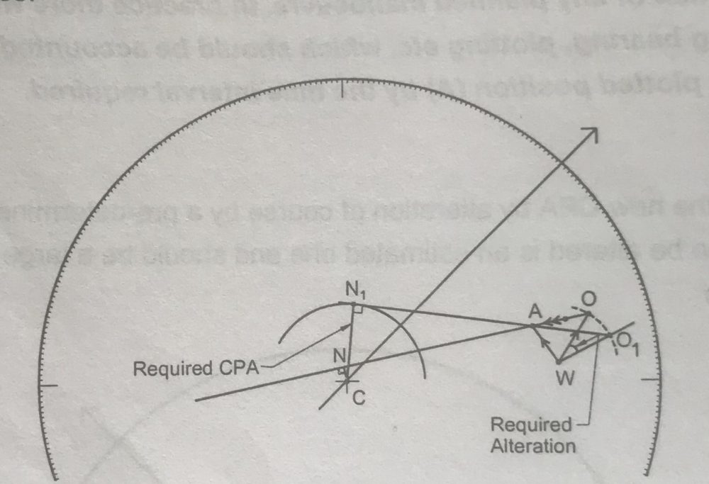
Objective
To determine the course to be altered to pass at the required CPA. Here the CPA may be determined as standard practice or may be dependent on the ships in the vicinity. Here again the CPA should be with a good margin to allow for eventualities.

- Make the basic plot. (OAW triangle)
- With C as centre, draw an arc with the CPA you desire. (All distances to be measured off the same distance scale)
Ensure you are complying with Collision Regulations when deciding any manoeuvre.
- Draw a tangent from the arc through point A, and extend it well beyond the WO line.
- From W cut off the distance WO on to this tangent. Name the point of intersection as O₁
- Join W and O₁.
- The angle OWO₁ is the amount of course alteration required to achieve the CPA required.
Objective
To determine the effect of the alteration of speed by a predetermined amount. Such alteration shall be consistent with the concept of safe speed and the circumstances of the case.

- Make the basic plot. (OAW triangle)
- From W measure the distance for the same time interval (new speed/time interval)
- Name this point as O₁.
- From O₁ extend line through A.
- Drop a perpendicular from C to this new line at N₁ . The new CPA is now indicated by the distance CN₁ .
Objective
To determine the alteration of speed that would need to be made to make a required CPA. As alteration of speed takes some time, it is advantageous to assume that the speed would be effective, say, after 2-3 minutes depending on the ships characteristics. The solved problem assumes immediate alteration for brevity but obviously it is not practical.

- Make basic plot. (OAW triangle)
- Draw an arc with the CPA you desire. (All distances to be measured off the same distance scale)
- Draw a tangent from the arc through point A, and extend it well beyond the WO line.
- Mark the point of intersection of this line with the WO line as O₁.
- Measure WO₁ —.this is the speed required to make the desired CPA.
Projected position
As stated earlier, all the previous examples assume no delay in the alterations that may be required to be made. However, practically there will be some time will be taken to note down the range and bearings of the target and then to make the radar plot, and subsequently in planning and executing the manoeuvre.
During this time, both the target and own vessel have travelled along their respective courses and this must be allowed for in the plot.
In other words:
- Plan the manoeuvre in a fixed time amount — say to be carried out after 6 minutes.
- Calculate the distance travelled by the target ship in this time interval (6 minutes) and plot this point P along the original OA line extended.
- Calculate Own ship’s distance travelled in the same time interval (6 minutes) and plot this Point W₁ along the original OW line extended.

Now consider the examples given above:
Alteration of course by a pre-determined amount
Steps 1 to 5 — no change
In step 6 — draw a line from O₁ through P well past the centre
In step 7 – Make a new CPA. by dropping a perpendicular from the centre onto the O₁P line.
Alteration of course to make a required CPA
Steps 1 and 2 — no change.
In step 3 – Draw a tangent from the arc through point P, and extend it well beyond the W₁O line.
In step 4 – From W₁ cut off the distance W₁O on to this tangent. Name the point of intersection as O₁
In step 5 – Join W₁ and O₁.
In step 6 – The angle OW₁O₁ is the amount of course alteration required to achieve the CPA required.
Alteration of speed by a pre-determined amount
Steps 1 to 5 — no change.
In step 6 – From W₁ measure the distance for the same time interval (new speed/time interval)
In step 7 – Name this point as O₁.
IN step 8 – From O₁ extend line through P.
In step 9 – Drop a perpendicular from C to this new line at N. The new CPA is now indicated by the distance CN
Alteration of speed to make a required CPA
Steps 1 to 5 — no change.
In step 6 – Draw a tangent from the arc through point P, and extend it well beyond the W₁O line.
In step 7 – Mark the point of intersection of this line with the W₁O line as O₁.
In step 8 – Measure W₁ O₁ — this is the speed required to make the desired CPA. Draw a tangent from the arc you just drew, and extend it well beyond the line W₁ O₁ .