Compliance of ECDIS system
ECDIS SOFTWARE VERSIONS
ECDIS that is not updated to the latest version of the IHO Standards may not meet the chart carriage requirements as set out in SOLAS regulation V/19.2.1.4.
Below is the list of latest ECDIS software versions available for various make and models. Please check the ECDIS software version on your ship and if the software is not of latest version.
| S.NO | MAKE | MODEL | Software Versions (COMPLIANT WITH PL VER 4.0) |
| 1 | JRC | JAN-9201 JAN-7201 | Application 01.20, Application 01.30, Application 01.40, Application 1.50 (All are PL Ver 4.0 compliant) |
| 2 | JRC | JAN-901B JAN-701B JAN-2000 | ECDIS Application Ver.03.00 Chart Portfolio Ver.03.00 |
| 3 | FURUNO | FEA-2X07 | 06.50, 06.52 (Both are PL Ver 4.0 compliant) |
| 4 | FURUNO | FMD-3100 | 03.xx, * 05.xx All of these software versions comply with IEC 61174 Ed.4. Any updates are NOT required from one to another among these. |
| 5 | FURUNO | FMD-3200/3200 BB/3300 | 03.xx, * 05.xx All of these software versions comply with IEC 61174 Ed.4. Any updates are NOT required from one to another among these. |
| 6 | TRANSAS | NS 4000 ECDISStandard & Premium | 3.00.340 (MNS 34),3.01.350 (MNS 35) |
| 7 | CHARTWO RLD | eGlobe G2 | version 1.1.1.10, 1.1.0.84, 1.1.1.17, version 2.0.0.44, 2.0.0.50, 2.0.1.0, 2.0.1.8, 2.1.0.8, 2.1.1.20, 2.1.2.25 All are PL Ver. 4.0 Compliant |
| 8 | SAM | NACOS PLATINUM | 32 Bit Architecture 2.1.03.33, 2.1.10.11 64 Bit Architecture 2.1.16.09 |
| 9 | Tokyo Keiki | EC-8600 EC-8100 K (Including – K type) | Ver.2.0.x EC-9019/9024/9027 |
| 10 | Raytheon Anschutz | NB44-014 | For the following Synapsis ECDIS processors the software version is: E02.05 950-040.NG001 (ECDIS 24) 950-019.NGxxx (Synapsis Box-PC) 950-014.NGxxx (NSC Box-PC) 950-011.NGxxx (A3300) For the following Synapsis ECDIS processors the software version is:E03.22 770-010.NGxxx (SMC) Current version of the ECDIS NX software for 770-010.NGxxx (SMC) is E05.6.x for 770-011.NGxxx (Panel PC) is E05.6.x |
CURRENT IHO ECDIS and ENC STANDARDS
| S.NO | EDITION IN FORCE | TITLE |
| 1 | S-57 Edition 3.1 | Transfer Standard for Digital Hydrographic Data |
| 2 | S-58 Edition 5.0.0 | ENC Validation Checks. |
| 3 | S-52 Edition 6.1(.1) | Chart Content and Display Aspects of ECDIS |
| 4 | PresLib Edition 4.0(.2) (Annex A to S-52) | Presentation Library for ECDIS |
| 5 | S-64 Edition 3.0.(3) (December 2020) | Test Data Sets for ECDIS |
| 6 | S-58 Edition 6.0.0 (May 2017) | ENC Validation Checks |
| 7 | S-61 Edition 1.0 (January 1999) | Product Specification for Raster Navigational Chart (RNC) (only if ECDIS software supports RCDS mode) |
| 8 | S-62 Current Edition | Data Producer Codes |
| 9 | S-63 Edition 1.2.(1)(March 2020) | Data Protection scheme |
| 10 | S-65 Edition 2.1.0 (May 2017) | ENCs: Production, Guidance Maintenance and Distribution |
| 11 | S-11 Part A Edition 3.1.0 | Guidance for the Preparation and Maintenance of International (INT) Chart and ENC Schemes |
IHO S-52 ECDIS Presentation Library Edition 4.0 Salient features
Refer to attached “IHO Advice for PSC Inspectors concerning IHO Standards” – ANNEX A for main Changes in IHO S-52 ECDIS Presentation Library Edition 4.0 and its benefits to the mariner’s onboard.
IHO CHECK DATASET
The main checks are as follows:
ECDIS and the IHO Presentation Library Edition Number
All ECDIS must have a function to display the edition number of the IHO Presentation Library that is in use within the ECDIS. All Mariners must familiarize themselves with the function in their ECDIS that will display the edition number of the IHO Presentation Library as this varies across ECDIS manufacturers. This function will be required when Port State Control officers want evidence that the ECDIS is up-to-date to the latest IHO standards.
ECDIS Chart 1 and IHO Presentation Library edition 4.0
For a graphical way to establish the ECDIS is correctly displaying the new symbols introduced in IHO S-52 Presentation Library edition, 4.0 the Mariner can check ECDIS Chart 1. ECDIS chart 1 is a legend of the entire set of symbols that may be used within an ENC. It is installed on all type approved ECDIS systems.
Only ECDIS updated to IHO Presentation Library edition 4.0 will be able to show the new ENC symbols. To check the ECDIS display Mariners are requested to open Chart 1, Information about chart display (A, B), and ensure they can view the symbols. ECDIS that have not been updated will not be able to display the new symbols. This is the IHO recommended method for checking that the ECDIS system can display the new symbols in IHO Presentation Library edition 4.0.
Following from Section VIII of Admiralty Weekly Notices to Mariners
ECDIS operating with Edition 4.0 of the IHO Presentation Library Performance tests during type approval and installation of the ECDIS demonstrates that the ECDIS does not have any of the identified display anomalies. The IHO check dataset is therefore not applicable. See iho.int for further information.
For a graphical way to establish that the ECDIS is correctly displaying the new symbols introduced in IHO S-52 Presentation Library Edition 4.0 the mariner can check ECDIS Chart 1. ECDIS Chart 1 is a legend of the entire set of symbols that may be used within an ENC, and is installed on all type-approved ECDIS systems.
LOG-Keeping requirements:
Vessels are required to maintain the ADMIRALTY ENC Maintenance Record (NP 133C). This log is designed by UKHO to streamline the management of paper records of ENC and ECDIS maintenance and make information on official digital charts more accessible for bridge team.
ENC Management Basics:
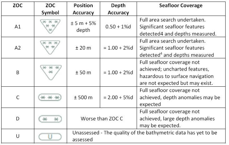
CATZOC and M_QUAL
When an ENC is produced, it is divided into areas. The accuracy of the data in these separate areas is based on the original source data with regards to positional accuracy, depth accuracy and sea floor coverage. These three sets of data are then assessed by the ENC producer together. Together they are then represented as one result, this is known as a “meta – feature”.
This meta-feature is called “Quality of Data” or M_QUAL. This M_QUAL is then given a symbol to show the ENC user the level of confidence for the data in that area, this is known as a Zone of Confidence or CATZOC. Once the M_QUAL is known, and the CATZOC zone is assigned to an area on the ENC, the navigator can view these symbols on the ENC usually in the “All / Other” display function on their ECDIS. The greater the number of stars that appear in the symbol, the greater the level of accuracy for that area.
To show the limits of individual surveys, the producer of the ENC can add Survey Reliability areas or _SREL, into the ENC data:
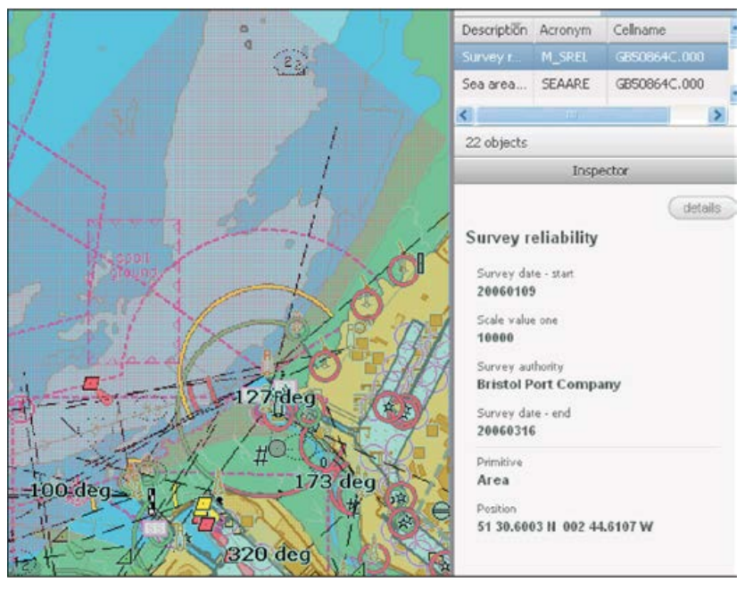
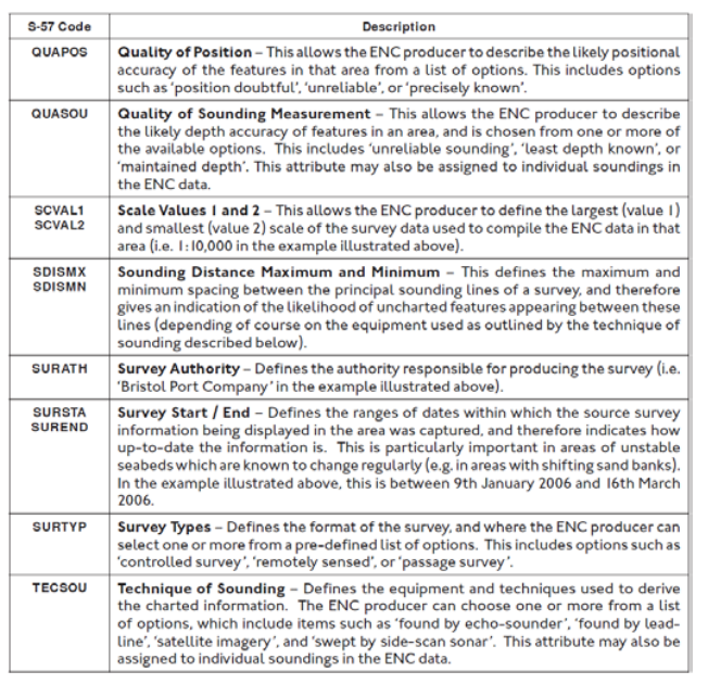
Once again, the producer can add much additional data to the M_SREL for the ECDIS user. The S-57 codes and descriptions are shown here for this data:
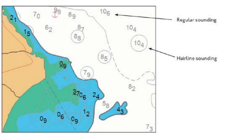
Charted Depths
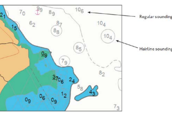
On an ENC, soundings from an unreliable source are circled as shown in below snapshot:
README Files
The user should know that general information on all the positional inaccuracies in the ENC can be found in the README file, it is recommended therefore that these are always referred to during the appraisal phases of passage planning. The ReadMe file should be filed in the relevant sub-section of NP-133C and discussed during the passage plan briefing.
Areas without ENC coverage
IHO provides an online chart catalogue that details the coverage of ENCs together with references to coastal State guidance on any requirements for paper charts (where this has been provided). The catalogue also provides links to IHO Member States’ websites, where additional information may be found.
The display on this catalogue of base maps from various sources does not constitute an endorsement or approval of them or of the information that they contain, and the IHO does not vouch for the validity or accuracy of these base maps.
UKHO do not currently publish a comprehensive list detailing area without ENC coverage. Please note that vessel can use either Planning Station or the Admiralty Digital Catalogue to assess areas, where ENC coverage is not available when planning routes and take necessary measures accordingly.
The changes in ENC coverage is very dynamic, it is strongly advised to check the planning station or the Admiralty Digital catalogue for latest information during passage planning.
In case if vessel has to call a port without vector chart coverage the raster chart should be ordered and used together with paper charts.
ADMIRALTY INFORMATION OVERLAY (AIO) Management
Currently, there is no unified approach by Hydrographic Offices (HOs) with regards to their approach about T & Ps on general ENCs. A number of HOs include the T & Ps in the weekly corrections of their ENCs, while others do not. There are some HOs that do not produce T & P notices and also some for which the status of T & P production and their incorporation is unclear.
Admiralty provides an option to users called Admiralty Information Overlay (AIO). The AIO feature is an optional additional overlay that can be turned on and off within ECDIS, independently of the display of ENC data. When activated it displays all the T & P notices produced by the UKHO as an overlay to the ENC and is intended to support passage planning and demonstration of compliance.
AIO features are shown as simple polygons drawn on top of the ENC data with a text description. Where necessary, text and picture files are included to provide further detail. The Navigator should assess them and decide if, for the safety of navigation, the Notice should be inputted as an actual manual correction.
Updating the Overlay:
Updates to the Overlay are issued weekly on CD, along with the weekly AVCS Update CD, and are also available over the Internet through planning /ENC station. Updates on CD should be loaded in the same way as loading ENC updates (see ‘Maintaining the Chart Outfit’ in the AVCS User Guide).
The data volume in each weekly update is normally small. However, it is necessary to issue a New Edition of the Overlay every 6 month, which consolidates all update data into a base data set. This New Edition may be over a hundred megabytes in size which will make it impractical for most users to download over the Internet and so an Admiralty Information Overlay CD should be used. Also, this New Edition Overlay CD must be installed before any further updates can be applied
Displaying the Overlay:
The Overlay is designed to be displayed on top of a standard ECDIS chart display and can be switched on and off without changing the underlying chart. Only those features relevant to the chart in use are displayed. As the user zooms in or out, the ECDIS will automatically select charts of a suitable scale and the Overlay features relevant to the selected charts will be displayed. For example, a Temporary NM that applies only to a large-scale chart will not be displayed when smaller scale charts of the same area are being used.
T&P NMs: New version of AIO does not include Admiralty T&P NMs that are only relevant to the paper chart users and those T&Ps which are included as temporary information in the ENCs. If the producer nation does not include temporary information in their ENCs but the UKHO has issued a T&P NM for an equivalent scale paper chart, then same will be included in the Overlay.
EP NMs: ENC Preliminary Notice to Mariners (EP NM) contain additional information that is specific to ENCs and cannot be published as a standard Admiralty T&P NM such as reported navigational hazards that have been incorporated on paper charts but have not yet been included in ENCs. These NMs are displayed in the same way as T&P NMs, as a polygon with a hatched fill which indicates the area affected by the NM. Each NM is allocated a unique EP NM number and is exclusive to AIO.
Area without AIO coverage
AIO also contains ADMIRALTY T&P NMs and highlights navigationally significant differences between ENCs and ADMIRALTY paper charts, published as ENC P NMs (or EP NMs). It does not contain NAVAREA Warnings or any other information.
Where there is no equivalent scale Admiralty paper chart, the UKHO does not have any additional information and the Overlay shows a ‘No Overlay’ feature. This feature is displayed as a grey polygon with a grey hatched fill/ horizontal gridline indicating the area where there is no overlay information.
T&P information is an essential part of ensuring that the charts in use are up to date. Many ENC producers include T&P information in their ENCs – there is a list in the INFO folder on the AVCS discs.
However, some do not, and even where it is included it can be difficult to identify. Please be aware that the T&P NMs shown in the Overlay relate specifically to ADMIRALTY paper charts and may not include all T&P NMs issued by the ENC producer. Areas where the UKHO does not publish T&P NMs are highlighted with a ‘No Overlay’ feature. Additional information, such as national T&P NMs, may be available in these areas from other sources and users should ensure that all appropriate sources of information have been consulted.
It is recommend that features that are significant to the passage plan should be plotted in ECDIS using Mariner’s Information Objects.
ENCs derived from charts on non-WGS84 compatible datum
Positions obtained from Global Navigation Satellite Systems, such as GPS, are normally referred to WGS84 Datum. In many parts of the world, however, charts were originally produced on a variety of local datums for which the shift to WGS84 may be unknown or unreliable. ENCs derived from such charts may not be accurately referred to WGS84 Datum. This can result in small but noticeable positional differences where adjoining cells have been shifted by slightly different amounts.
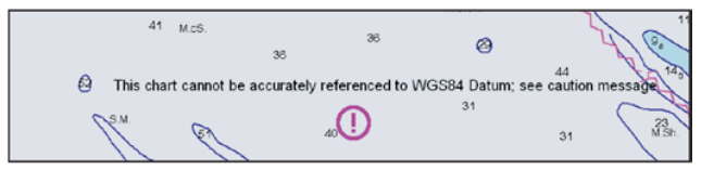
A number of Indonesia (ID) and UK (GB) ENC’s are derived from charts that cannot be accurately referred to WGS84 Datum. The differences between satellite-derived positions and positions on these cells cannot be accurately determined; the estimated values of the differences for these cells are detailed in the Information attribute of Caution Areas thus: “Positions in this region lie within ± nn meters of WGS84 Datum”. Mariners are warned that these differences may be significant to navigation and are therefore advised to confirm GPS positions shown in the chart display using alternative navigational techniques, particularly when closing the shore or navigating in the vicinity of dangers. Such cells contain a warning encoded as the name of a Sea Area feature covering the cell thus: “This chart cannot be accurately referenced to WGS84 Datum; see caution message”. They are intended for use with this warning continuously displayed and should not be used otherwise.
Common operational concerns:
When properly operated, ECDIS is an exceptional tool that drastically improves situational awareness and operational efficiency and can reduce errors. On the other hand, over-reliance or lack of familiarity can lead to calamitous consequences.
The term “ECDIS assisted Grounding” has not arisen from nowhere, and based on our experience, recurrent themes often include the following:
- Improper use of charts: i.e. not using or having the necessary charts for the intended voyage or not applying chart updates frequently and correctly.
- Not following or being aware of the manufacturer’s software maintenance updates and not updating the ECDIS to be compatible with the latest version of the IHO Standards.
- Improper use of safety settings and built-in safeguards such as route checking and safety alarms related to depths.
- Improper display settings, filters and scale.
- Not using the route checking function at all or not using it with an appropriate Cross Track Distance (XTD). Not visually checking the route at an appropriate scale.
- Lack of familiarity with the specific ECDIS type onboard.
- Over-reliance on ECDIS and the displayed GPS position.
- Inability to use or lack of familiarity with manual position fixing functions such as range and bearings.
Few other important aspects:
- A base ENC with limited chart information compared to the unfiltered chart of the same channel and location. Overuse or improper use of filters and contours may result in ambiguous displays of soundings and potentially dangerous interpretations.
- Manual position plotting can be done quickly and easily on an ECDIS, but it is critical that officers familiarise and regularly practice this function. GPS positions should be cross-referenced using visual/ radar range and bearings.
- Consistent Common Reference Point (CCRP) settings and locations of antennas, radars and other reference points should be frequently checked to ensure the settings are correct. Refer Manual for carrying out the checks and ensure no settings are changed by ship. These settings are password protected.
- When Cross Track Distances (XTD) are properly set to each leg of a voyage plan then route checking assists in checking for potential obstructions, dangers and insufficient depths.
Hardware and component
Details of the planned maintenance schedule for the ECDIS (software and hardware) and timetable for periodic tests are included in the PMS for all ships.
ENCs Updating and Back-up Arrangements
The UKHO’s weekly updating service for ENCs includes the latest updates issued by all the contributing Hydrographic Offices. These updates may or may not be synchronised with Notices to Mariners and New Editions produced for their national paper chart series. In some cases, therefore, ENCs may be more or less up to date than the corresponding paper chart of the same area.
The ADMIRALTY Information Overlay (AIO) provides easy reference to T&P information, this can be
displayed on a range of ECDIS or on back of bridge systems such as ADMIRALTY e-Navigator. When ECDIS is fitted, arrangements must be in place to ensure that a safe transition can be made to a back-up system in the event of an ECDIS failure. The back-up system must also ensure safe navigation for the remainder of the voyage. A second, independent, ECDIS or paper charts are the normally accepted solutions. Details will be entered on the Record of Equipment.
The back-up arrangement must be ready for immediate use. If paper charts are used, they must be readily available with the voyage plan indicated on them. If the back-up is a second ECDIS, it must be loaded with the relevant up-to-date ENCs and current voyage plan.
The Back-Up system will be listed in the Record of Equipment by the Flag state or classification society.
Familiarization of officers
In addition to generic and vessel specific ECDIS training, the Master and all watch keeping officers must be familiar with the specific ECDIS installation on board the vessel they are serving. This familiarization will include the backup systems, sensor configuration, and level of integration and current operational status of the ECDIS.
External Inspections
PSC Inspectors focus on how the ships meet the SOLAS requirements for chart carriage and the safe and effective conduct of navigation tasks.
ECDIS – What are the main questions of PCS inspectors to deck officers?
- Demonstrate software compliance to S 52 Pl edition 4.0. Show Chart 1 as set up to.IHO guidelines. Show a latest type approval certificate
- Show ECDIS contour setting policy, planning and implementation for various critical legs.
- Show planning of Chart alert / Look ahead planning and implementation for various legs
- Show that ENCs have valid permits, are of latest edition and have the latest Weekly updates applied.
- Show that T& P corrections (where required to be done by OOW) are being appropriately done by manual update.
- Demonstrate multiple means of position fixing and verification (with LOPs, cross bearings, PI lines and other tools)
- Demonstrate procedure of manually feeding critical sensor data in case failure same being received automatically.
- Show relevant chart annotations like alarm enabled no go areas, P I lines, contingency anchor etc.
- Show a route plan involving vessel’s passage within and across a safety contour area.
- Is CATZOC being factored during UKC calculation.
- Show past track, log books, Playback (if available)
- Show record keeping like maintaining NP 133C.
- Show records of equipment specific familiarization / training for OOWs.
- Show the up to date ENC / AVCS maintenance software (like Voyager etc)