Buoyage Module
Introduction – Interest and Need
In previous lessons we have looked at how to fix the ship during the daytime using a number of differing means. There are a number of other aids by which to keep a ship safe and we will look at these now. First we will look at the Buoyage that is found around our coast and provides us with a useful aid to navigation. Note that buoyage is only an aid to navigation and does not relieve the Master / Captain of knowing exactly where he is.
Range of Lesson
During this lesson we will cover the following:
The IALA buoyage system Region A.
The general and local direction of buoyage.
The characteristics of the different buoys and lights used in this system.
Abbreviations used on charts.
Objectives
By the end of this lesson you will be able to identify lights, fog signals, and the IALA Buoyage System (Region A) by day and night. You will be able to state the meaning of and identify general light characteristics, use ALLFS to a basic level, state the use and limitations of fog signals, and determine the meaning of and be able to pass the safe side of IALA Buoyage (Region A).
IALA – International Association of Lighthouse Authorities
IALA is a non-governmental body which brings together representatives from the aids to navigation services in order to exchange information and recommend improvements to navigational aids based on the latest technology.
One of the most taxing situations that a mariner will encounter is when he is confronted unexpectedly at night or in low visibility by the lights marking an uncharted danger, such as a recent wreck. Immediately he must instinctively, positively and correctly decide what he must do.
In the Dover Strait in 1971 the Brandenburg struck the wreckage of the Texaco Caribbean and sank, though the wreckage was appropriately marked. A few weeks later the wreckage, despite being marked by a wreck marking vessel and many buoys, was struck by the Niki, which also sank. A total of 51 lives were lost. It was this disaster which gave rise to the development and implementation of the IALA Maritime Buoyage System.
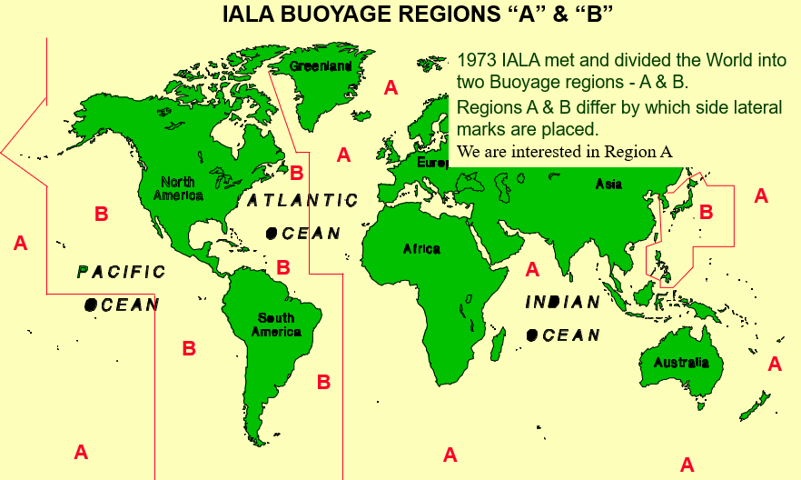
IALA Buoyage Regions A & B
In 1973 IALA met and divided the world into two buoyage regions, A and B. The regions differ by which side lateral marks are placed. We are interested in Region A.
The IALA System
The system applies to all fixed and floating marks, other than lighthouses and sector lights. It serves to indicate sides and centrelines of navigational channels, navigational channels under fixed bridges, natural dangers and other obstructions such as dangerous wrecks, areas in which navigation may be subject to regulation, and other features of importance to the mariner.
Types of Marks in IALA Region A
To meet the requirements of the system, five different types of mark are provided:
Lateral marks, Cardinal marks, Isolated danger marks, Safe water marks, and Special marks.
Lateral Marks
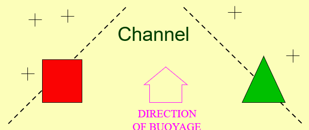
Lateral marks are generally used for well-defined channels in conjunction with the direction of buoyage. They indicate the limits of channels on the port and starboard sides.

If you are going in the direction of buoyage shown on the chart, green buoys will be to starboard and red buoys to port. If you are going in the opposite direction, the positions will be reversed.
Direction of Buoyage
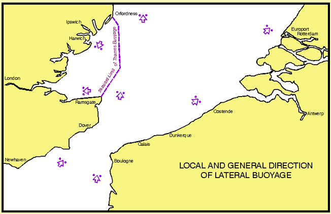
Local Direction of Buoyage is the direction taken by the mariner when approaching a harbour, river, estuary or other waterway from seaward. Under IALA A, port hand buoys are on the port side when entering harbour.
General Direction of Buoyage is determined by buoyage authorities and is based on a clockwise direction around continents. Around the British Isles, the general direction is from southwest to northeast.
Starboard Lateral Marks
Starboard lateral marks are green in colour and are cone-shaped or have a conical topmark. If numbered, they are odd numbered. If lit, they show a green light with any rhythm except 2+1.

Port Lateral Marks
Port lateral marks are red in colour and are can-shaped or have a can-shaped topmark. If numbered, they are even numbered. If lit, they show a red light with any rhythm except 2+1.

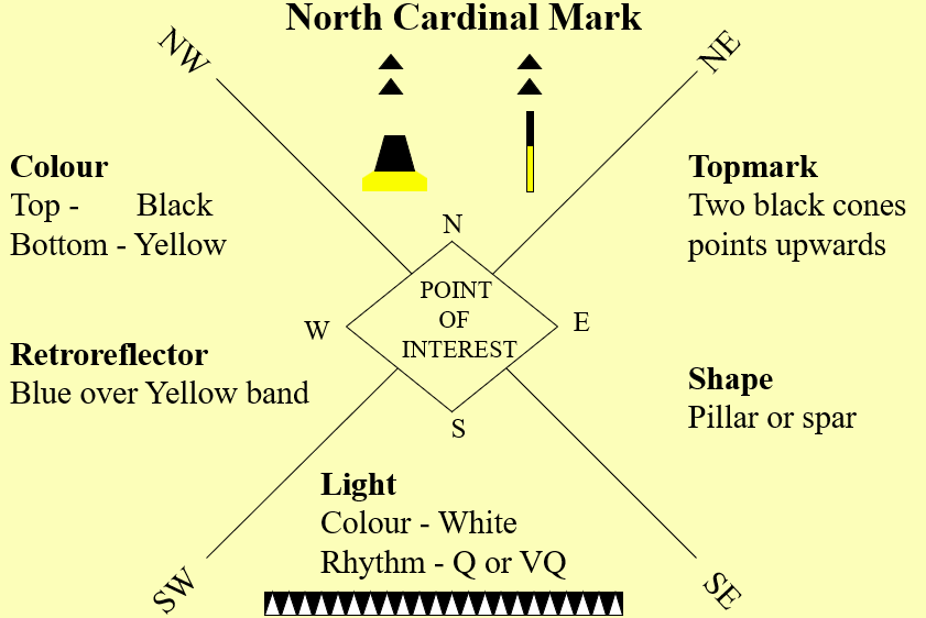
Cardinal Marks
Cardinal marks are used in conjunction with the compass to indicate where the mariner may find the best navigable water. They are named North, East, South or West depending on where the safe water lies.
They are yellow and black in colour and have a topmark of two black cones. The cones point towards the black band on the buoy.

Recent wrecks are often marked with four cardinal buoys so that the wreck cannot be passed over from any direction.

North Cardinal Mark
The North Cardinal Mark has a black top and yellow bottom. The two black cones point upwards. If lit, it shows a white light with a quick or very quick flashing rhythm.
East Cardinal Mark
The East Cardinal Mark has black, yellow, black horizontal bands. The cones point away from each other. If lit, it shows a white light with Q(3) or VQ(3).

South Cardinal Mark
The South Cardinal Mark has a yellow top and black bottom. The cones point downwards. If lit, it shows a white light with Q(6)+LF or VQ(6)+LF.

West Cardinal Mark
The West Cardinal Mark has yellow, black, yellow bands. The cones point together, resembling a wine glass. If lit, it shows a white light with Q(9) or VQ(9).
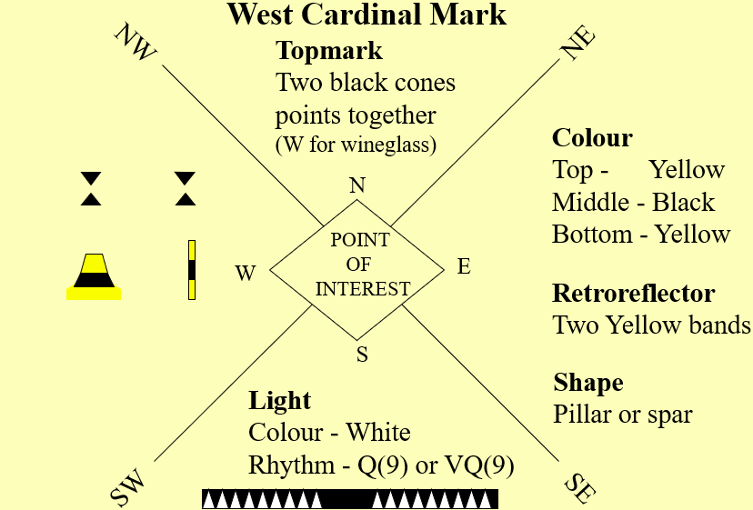
To remember the light sequences think of a clock face, the long flash
immediately after the group of flashes of a South Cardinal mark ensures that 6 flashes cannot be mistaken for 3 or 9.

Isolated Danger Marks
Isolated danger marks are erected on or above isolated dangers with navigable water all around. They are black with red bands and have two black spheres as a topmark. If lit, they show a white group-flashing light (2).

Safe Water Marks
Safe water marks indicate navigable water all around. They are red and white striped with a single red spherical topmark. If lit, they show a white light with isophase, occulting, long flash, or Morse Code A.

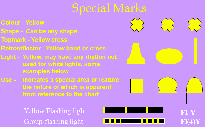
Special Marks
Special marks are yellow in colour with a yellow X topmark. They indicate special areas or features identified on the chart, such as spoil grounds, cable areas, military exercise zones, or recreation zones.
Characteristics of Lights
There are four main characteristics of lights: rhythm, colour, period, and intensity.
Rhythm describes how the light appears, such as flashing, quick flashing, occulting, isophase, or Morse code. Colour may be white, red, green, yellow, blue, or violet. Period is the time taken to complete one full cycle of light and darkness. Intensity is the brightness of the light, measured in candelas, though charts usually give nominal range.
Characteristics of Lights – PERIOD
The period of a light is the time taken to complete one full cycle of ON-and-OFF changes.

Characteristics of Lights – INTENSITY
A measure of the brightness or power of the light. The standard unit of measurement is candelas. However, on the majority of charts and on all British Admiralty Charts, the Nominal Range of a light is given.
INTENSITY – measured in candelas. Each light is fitted with a bulb or filament of fixed power or brightness.
Lights – Range of Visibility
The range of visibility is dependent on the intensity of the light, the prevailing visibility, and the height of the light combined with the height of eye of the observer.
The most important factor that needs to be known is how far away you will be able to see the light. This is broken down into three areas.
Lights – The Intensity
The brighter the light the further it can be seen.
The range is based on visibility being ten nautical miles and this referred to as luminous range.
Bearing in mind that visibility is rarely exactly ten nautical miles and that your height of eye may not be sufficient to overcome the curvature of the earth; the ranges given on charts should be used only as a rough guide. Exact calculations can be made with reference to tables contained in ALLFS and this will be taught to the seamen amongst you later in your careers.
Lights – Prevailing Visibility
The range of a lights given on the chart or in Admiralty List of Lights & Fog Signals (ALLFS) is based on visibility being 10nm, this is referred to as the Nominal range.
Visibility is rarely exactly 10nm so the ranges given on Charts are a rough guide.
The range is based on visibility being ten nautical miles and this referred to as luminous range.
Bearing in mind that visibility is rarely exactly ten nautical miles and that your height of eye may not be sufficient to overcome the curvature of the earth; the ranges given on charts should be used only as a rough guide. Exact calculations can be made with reference to tables contained in ALLFS and this will be taught to the seamen amongst you later in your careers.
Lights – Height of Light and Height of Eye
The height of the light is also given on the chart or in Admiralty List of Lights & Fog Signals (ALLFS).
The height of the light and the range are given on the chart or in Admiralty List of Lights and Fog Signals (ALLFS). Heights of eye will vary on different ships and may be insufficient to overcome the curvature of the Earth, therefore the range of the light should again only be used as a guide even when visibility is at 10nm.
Characteristics of Lights – Geographical Range
Range of a light taking into account the height of a light and the height of the observer.
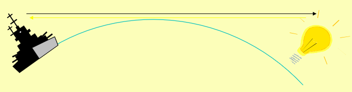
Chart Symbology
By combining the various characteristics it is possible to have a large number of lights within a small area that are all easily identifiable.
Advantage is taken of this to provide the necessary distinction between aids in the same area.

Characteristics of Lights – Chart Examples
Fl (6) 30s.
A group of 6 white flashes every 30 seconds.
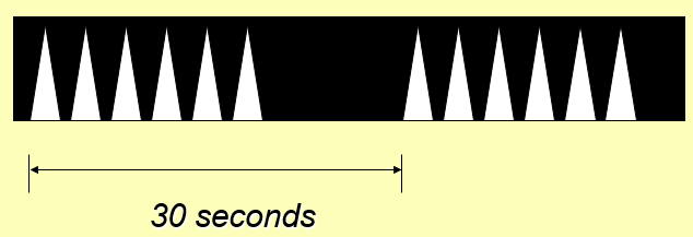
Chart Examples
Oc Y 12.5s.
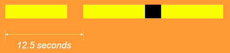
A Yellow light with one Occultation every 12.5 seconds.
Chart Examples
F G.

A fixed green light.
Chart Examples
Iso R.

A red light with an equal duration of light and darkness (Isophase).
Characteristics of Lights – Sector Lights
Finally a light that is not covered elsewhere is the sector light. This is a light presenting different appearances, either of colour or character, over various parts of the horizon of interest to maritime navigation.
Remember that the limits of sectors and arcs of visibility are given as seen by an observer from seaward.

ADMIRALTY LIST OF LIGHTS AND FOG SIGNALS.
All of the information that we have discussed for lights is covered in this publication. It also gives you a physical description of the light structure so that during the hours of daylight when the light is not visible you can use the structure for fixing or a headmark.
Fog Signals – Limitations
Fog signals give an invaluable warning of danger but their use for navigation is limited.
Fog signals may be heard at greatly varying distances. They are affected by atmospheric conditions. There may be areas of inaudible sound. Fog signals may be unoperable at very short notice. They give no accurate bearing or range information.
Sound travels in unpredictable ways and the following points should be noted.
Fog Signals – Chart Abbreviations
Abbreviations of fog signals found on charts:
Dia
Siren
Reed
Explos
Bell
Gong
Whis
Horn
Summary
During this lesson we have covered the following:
The IALA buoyage system Region A.
The general and local direction of buoyage.
The characteristics of the different buoys and lights used in this system.
Abbreviations used on charts.
Objectives
You should now be able to:
Identify lights, fog signals, and IALA Buoyage System (Region A) by day and night.
State the meaning of and identify general light characteristics.
Use ALLFS to a basic level.
State the use and limitations of fog signals.
Determine the meaning of and be able to pass the safe side of IALA Buoyage (Region A).