AIS is a system that transmits vessel position, course and speed via a VHF radio channel to all ships within range (typically up to 30 miles). It also receives similar information from other AIS equipped vessels within range.
Automatic identification system (AIS) is fitted aboard ships on international voyage with 300 or more gross tonnage (GT), and all passenger ships regardless of size.
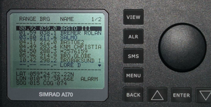
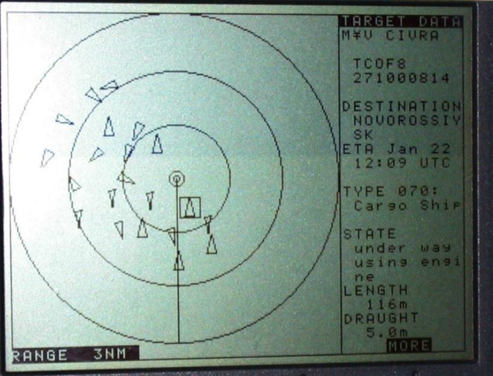
This enables the AIS system to display , on an ECDIS, all participating ships, within range, including their name, location, course and speed.
As the display system is computer based, it can monitor the reported course of nearby vessels and raise an alarm if a vessel is predicted to approach your ship too closely.
AIS System

An AIS system consist of the following parts:
- Transmitter
- Two receivers
- Controller
- Display Unit
The AIS must constantly receive information on ships course made good (CMG), speed over ground, latitude, longitude along with time stamp.
Some AIS units achieve this with a built- in GPS, others rely on feed from an external GPS. Information like course steered, speed over water are provided by GYRO Compass and Speed log respectively.
AIS Working principle
For AIS to work successfully it needs to be supplied with appropriate variable inputs: heading, latitude and longitude and speed.
The AIS will constantly monitor its inputs and raise an alarm if one of its input fails.
Received AIS messages are now recorded on the vessels VDR but utilized by the ship’s radars and ECDIS.
AIS messages are usually transmitted to these other equipment’s by NMEA 0183 but other networking systems can be used.
All equipment that makes use of AIS messages will be checking the quality of signal and lack or presence of a signal and will raise an alarm if the AIS messages fail to be received.
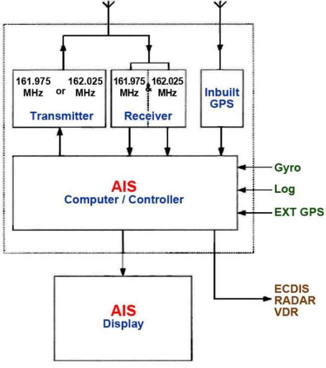
Figure shows a block diagram of an AIS.
Two receivers are constantly monitoring two marine VHF channels (161.975 and 162.025 MHz).
The controller builds up a list of time slot activity for each channel.
When ready , the controller selects the best transmit channel by using a complex computer programme.
The controller assembles heading, speed and position data, appends fixed data such as MMSI, calculates a checksum and sends the sentence.
Any received information from other vessels is displayed on the screen.
AIS Data Transmission
AIS gathers all of the required information, static and dynamic, constructs a sentence of information, then listens for an empty ‘slot’ to transmit in.
There are over 2250 time slots in each of two channels

Sophisticated software is constantly monitoring all slots on both channels to receive other ship AIS messages, and uses the information gained to decide which channel and which time ‘slot’ to use.
Ships with a self-organizing broadcast AIS onboard see each other as soon as they are in radio range.
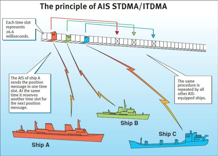
STDMA system
AIS
The STDMA system is described as number of vessels, fitted with AIS.
All know their own position by receiving signals from own GPS.
The AIS of each ship transmits its position, vessel course, navigational status described as “statuc and dynamic data” in a later section etc.
VHF Transceiver
Each vessel AIS is equipped with two very high frequency transceiver which is used to communicate the “own position” speed and course and more (static and dynamic data).
All other vessels share a common frequency channel 161.975 and 162.025 MHz.
Time Base
The GPS, which are used for positioning, also provide a time base to the vessels.
The time base is used to divide the common frequency channel into time slots.
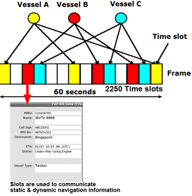
A 60 second base called frame is shown here.
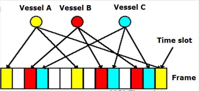
VHF Channel access
The communication channel is divided into a frame of 60 seconds, consisting of a 2250 time slots.
Refer to the diagram, for example each vessel A,B & C is able to autonomously allocate slots within the frame.
The slots are then used by each moving object, to communicate the own position, speed, course and other information also called static & dynamic data.
Cellular Concept
Each vessel operated in a communication cell. A vessel is primarily interested in information on vessels within its vicinity (nearby) for navigation safety.
The range of the AIS radio wave is thus restricted. The AIS system uses, VHF channels 161.975 and 162.025 MHz.
Slot allocation
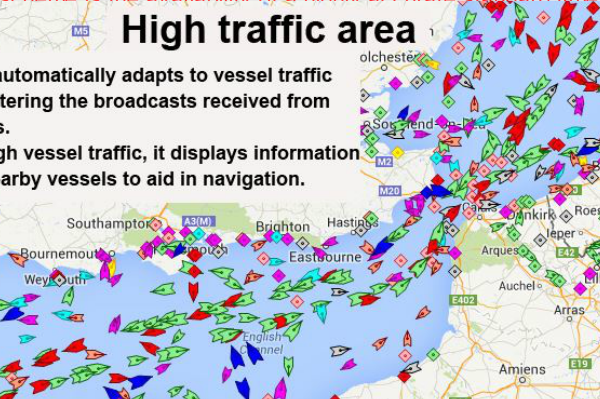
Slots are allocated automatically by AIS computer / controller, which will primarily select unused slots. AIS automatically adapts to vessel traffic.
The key to the STDMA scheme is the availability of a highly accurate standard time reference, to which all stations can synchronize their slot assignments. This is provided by the GPS. Thus GPS plays a crucial role in AIS.
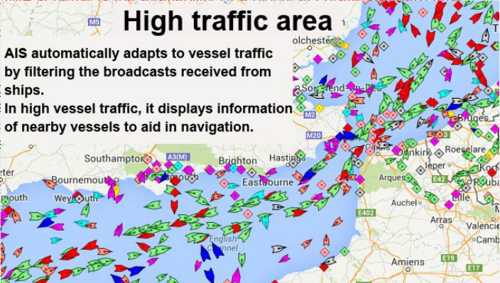
In dense traffic, if the number of the AIS messages begins to overload the network, the ship’s AIS system can automatically use slots, occupied by vessels, which are far away and retain the slots of vessels in the vicinity (nearby) to provide important information for safe navigation.
Interval of broadcast
The slots are used in order to broadcast the own position.
Because the vessels are moving, the dynamic data such as position, course, speed may change, therefore AIS messages must be updated and retransmitted every few seconds at a minimum, because the usefulness of the data decays rapidly as time passes.
Each vessel will have a default transmission rate, which can be changed automatically or via master control depending on the speed of the vessel.
It varies from 3 minutes at anchor to every 2 seconds for a 23 knot vessel.
Data Transmitted By AIS
Static Data
When AIS is installed , the technician programs the ship’s permanent details into the system and do not normally change.
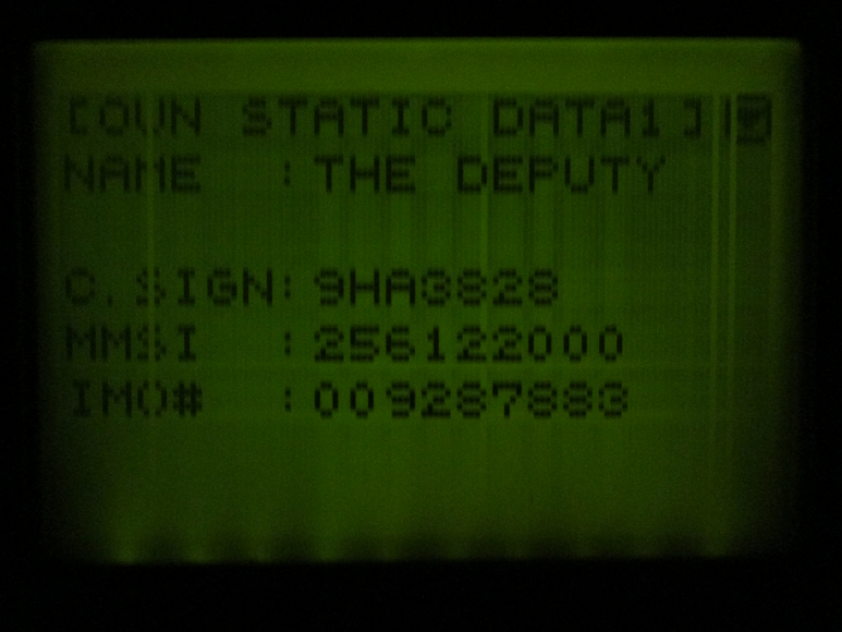
- MMSI (Maritime mobile service identity) number
- IMO number
- Call sign and name
- Length and beam
- Type of ship
- Location of position fixing antenna on the ship
Dynamic data
These are collected from various electronics navigational equipment through sensors.
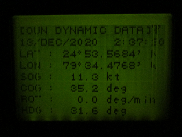
- Ship position with accuracy indication and integrity status
- Time in UTC
- Course over ground
- Speed over ground
- Heading
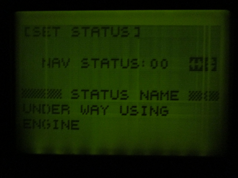
- Navigational status (eg. At anchor / NUC) – Manually entered
- Rate of turn (where availaible)
Voyage related data
These data are fed in y the ships crew and will change from voyage to voyage.
- Ships draft
- Hazardous cargo
- Destination and ETA
Safety related messages
- Short safety related messages of fixed or free format addressed either to specified destination (using MMSI number) or to all station in the area.
Data transmission Interval
The static and voyage related data are transmitted every 6 minutes or when amended or when requested or interrogated by a VTS.
Safety messages are sent as required.
The update rate of dynamic information depends on the ship’s navigational status and speed, as per the following schedule
- At anchor : 03 minutes
- 0-14 kts : 12 seconds
- 0-14 Kts and changing course : 4 seconds
- 14-23 kts : 6 seconds
- 14-23 kts and changing course – 2 seconds
- 23 kts and faster – 3 seconds
- 23 kts and faster and changing course – 2 seconds.
Caution
- AIS most importantly, increases situational awareness on the bridge.
The officer of the watch on an AOS fitted vessels can positively identify another vessel in the vicinity and have details about their movement and navigational status.
This greatly improves the quality of decision taken special at a critical moment to avoid navigational incidents.
AIS data is an aid to navigation however it should not be used fro collision avoidance purpose.
AIS can detect other ships beyond radar obstructions, therby provides early warning of an incoming vessel specially around a bend.
AIS Play a major role in ship reporting system. The information required by coastal authorities in such systems is typically included in static , dynamic and voyage related data automatically provided by the AIS.
AIS may be used in search and rescue (SAR) operations, especially in combined helicopter and surface searches.
AIS allow direct presentation of the positions of the crafts involved in SAR and the distressed craft.
When fed to radar and / or ECDIS the SAR operation becomes much simpler with real time positions and movement vector at any time.