90% of all the shipping casualties occur in coastal and port areas. The coastal passages leading to ports are generally the most dangerous portions of vessel voyages and vast majorities of marine casualties occur during this passage. It is therefore imperative that the bridge team and the pilot both are totally prepared for the passage and monitor it throughout the passage with proper planning and understanding.
Why port approaches require passage planning
i) Greater risk of collision due to increased traffic densities and geographical bottlenecks.
ii) Increased risk of grounding. iii) Ships of higher tonnages more prone to navigational and mooring risks. iv) Minor human errors could cause major accidents, as the time needed to apply correction is very little.
Three phases of passage
Transition of a ship sailing from the open seas to the berth (mooring) at a terminal can generally be divided into three parts or phases in accordance to the manoeuvres to be performed and the configuration of the specific coastal area They are:
i. Passage from sea to port approaches/ pilotage grounds. ii. The manoeuvres in the port, and iii. Approach and mooring at the berth.

We are concerned with the activities of the bridge team in these three phases, 50 that the task of bringing the ship from sea to berth (and vice versa) can be completed successfully with the pilot’s assistance.
Prerequisites:
a) The Bridge team are familiar with the basic manoeuvring and propulsive characteristics of their ship, particularly stopping distances and turning circles at:
i. Various speeds ii. Drafts and trim conditions, and iii. Under the effects of external conditions as wind, currents, sea and swell.

b) Familiarity with horizontal and vertical dimensions of the port approaches, accesses and manoeuvring areas of the port, pilot station and its approach channels. Details such as widths, depths, bends etc, anchorages, emergency anchorages turning circles etc should be studied and noted.
c) Knowledge of berthing procedures in ports.
d) Environmental conditions at port such as tides, currents, waves and swell, winds,
e) Shallow water effects expected etc.
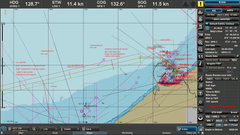
Vessels navigating in VTS areas
Decisions concerning the actual navigation and the manoeuvring of the vessel remain with the master. Master has the overall authority to override the VTS sailing plan or request changes to the agreed plan.
Sea to Berth-Plan
On approaching the port the ship is required to test its steering gear and the capability of the main engines to ensure safety of the ship and pollution prevention.
Master gives specific instructions on maintaining appropriate margins of safety, including minimum distance from the coast and underwater hazards, in case the ship looses propulsive power or steerage capability.
The appropriate minimum offshore distance will depend upon many factors, including:
- the reliability of hydrographic information
- the available sea room
- the density of traffic
- forecast and actual current, tidal stream, wind, swell and visibility
- operational requirements including pilot boarding arrangements, shelter from adverse weather, and use of recognized routes through narrow channels
- the adequacy and reliability of navigation aids
- the reliability of the main and auxiliary power and steering systems
- the ability to anchor,
- The likely direction and rate of drift
Port Passage Plan
Port passage plan has three elements.
- Sea to pilot boarding ground,
- Pilotage proper,
- Berthing Manoeuvres
Why a passage plan or port passage plan?
To improve safety of ship movement through:
- Pre-identification of local hazards and ship characteristics,
- Sharing information between Master, Pilot and traffic control,
- Promote bridge team work and
- Reduce the possibility of misunderstanding and human error.
HUMAN ERROR plays significant part in maritime casualties. Some aspects of the same were covered previously.
An important aspect when dealing with bridge team management is the need to avoid single point failure i.e. wrong action taken by a Pilot, Master or OOW should be detected and controlled. For instance, if there is a deviation from intended track, then even an OOW should be in a position to question the pilot as to why the indicated track is not followed.
A port passage plan describes critical details of the intended passage appropriate to the vessel using it in a form that can be understood by the bridge team in advance. This could be either in writing or on a chart and serve as a basis for agreement between the master and pilot with details being passed to traffic control.
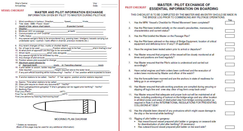
Master Pilot Exchange (MPX).
Person I / C of- Traffic control should exchange information regarding:
- Navigational procedures,
- Local conditions,
- Ship characteristics.
The master and pilot have an obligation to exchange information following the boarding of the pilot.
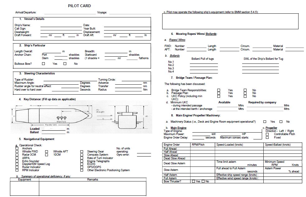
Ship to Pilot – Master provides the pilot with details of the vessel, its status, and performance and pertinent equipment. He may use the formats specified herein.
Pilot to ship – Pilot provides information about the intended passage, describes critical details of the intended passage appropriate to the vessel. Such information may use a form that can be notified to the master in advance either in writing or on a chart.
Ports are now encouraged to publish Port Passage Plans. Such passage plan may include:
- Information from a general simple plan for an entry to port to elaborate plans to a particular berth giving ship sizes, conditions of berthing-unberthing and staying along side, tidal constraints, tug allocation, holding area etc.
- Critical port movements–deep draft vessels to particular berth,
Publication of port passage plans could be published in Admiralty Sailing Directions, Adm. List of Lights, Local Notices to mariners, Port Handbooks to minimize the need for radio communication with arriving vessels.
Operation of port passage plans:
A port passage plan may include:
- An optimal route and approach to berth (details given shall depend upon ship size, critical areas and tidal conditions).
- The vessels own passage plan and changing circumstances. (The Port passage plans will have to be dynamic to take this into account )
- Aspects of the plan for entry in restricted waters or departure therefrom. (These should be discussed and agreed with master and notified to port control.)
- Ship details that the pilot needs for his plans- including any particular characteristics or defects which may affect navigation.
- Port details that the Master needs for his plans- including general requirement, the latest tide and weather report or any other special condition or restrictions.
The Port Passage
- Pilot normally boards at sufficient distance from the commencement of the pilotage to allow the creation of safe boarding conditions. However if the boarding operation are to be carried out in closer waters Master shall ensure that sufficient sea room is available for pilot boarding operation so that in an emergency they can be safely aborted.
- Sufficient time be available for the pilot to fully familiarize with the manuoverabilty of the ship and the existing situation
- Sufficient time be available for the master, bridge team and pilot for full exchange of information.( such information needed shall be prepared / calculated when preparing passage plan)
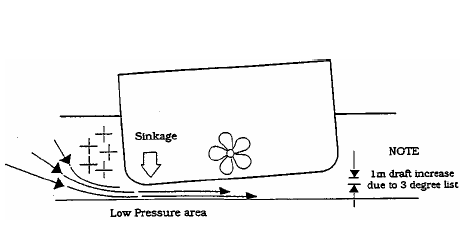
- Ensure that the depths in approach channels and pilot boarding ground are adequate considering tidal heights and other environmental factors. The depths should satisfy the following criteria of squat:
- Open sea areas exposed to strong, long stern or quarter swell and high speeds: – 20% of the deepest draft.
- Channel and waiting areas exposed to strong and long swell-15% of the deepest draft
- Channels less exposed– 10% of the deepest draft.
- Adequate channel widths are available. The requirement of the widths is dependent upon environmental conditions such as cross currents and waves, swell, wind, visibility.
- Minimum channel width-shall be as follows
| Without Cross Currents | Width at full depth |
| One way traffic | 5B (In practice 4B to 10B |
| Two way traffic | 7B to 10B – Biggest ship |
7. Channel Layouts shall satisfy the following criteria:
| Curve radius should | not be less than 10L – Biggest ship |
| Turning circlse or basins | not less than 4L (without tugs) or 2L with adequate tugs |
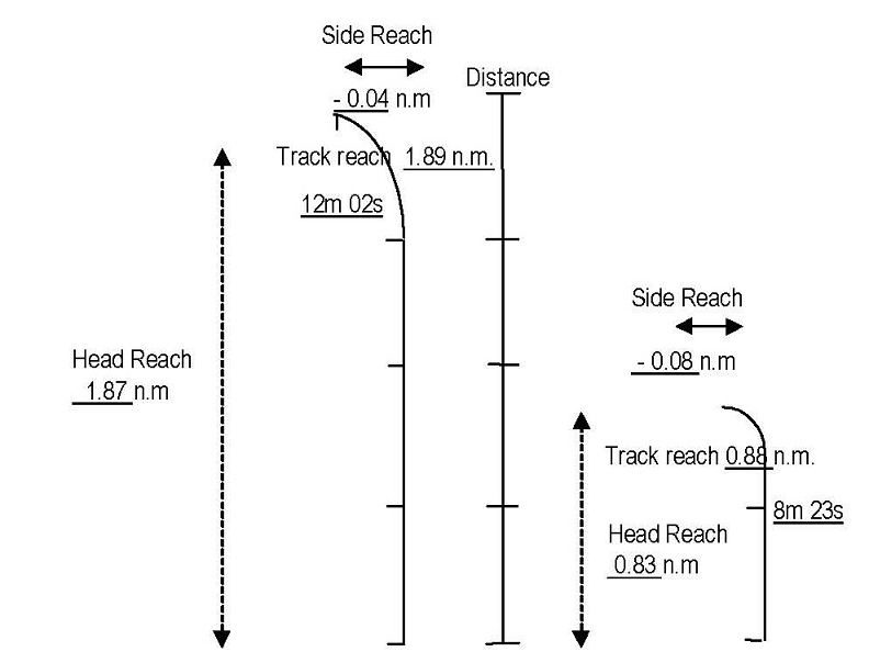
| Stopping distance | 3 to 4 km for the largest ship with tug assistance to stop |
- Lay byes and anchorage – for emergencies shall be provided.