Skip to content

Knowledge Of Sea

We will keep you updated

  • Home
  • Video
  • Chartering Terms
  • Rule of the Road (COLREG)
    • Nautical Flags
    • Rule of the Roads – CARDS
  • Tanker Definitions
  • Downloads
  • ORAL NOTES
    • ORAL NOTES- 2ND OFFICER
    • ORAL NOTES- CHIEF MATE
    • ASM ORAL NOTES 1
    • ASM ORAL NOTES 2
  • About Me
  • Exit Exam
    • FPFF exit exam questions and answers
    • EFA exit exam questions and answers
    • BST exit exam questions and answers
    • AFF DG Shipping exit exam question and answers
  • ASM ORAL NOTES 3
  • Toggle search form
parallel indexing

Parallel Indexing

Posted on April 5, 2021April 5, 2021 By admin No Comments on Parallel Indexing

Parallel indexing is an effective way of monitoring a vessels progress along a preselected track using a radar.

As a vessel moves on its chosen heading, fixed objects in its radar vicinity appear to be moving in a reciprocal direction to this motion. This technique provides the radar observer with a real time view of the ship’s lateral position relative to the planned track. The approach can be used in all conditions of visibility to monitor the vessels cross track movement.

The following must be confirmed before employing the radar in this way:

  • The performance of the radar must be checked at regular intervals.
  • Gyro errors must be checked
  • Heading marker should be in alignment with the ship’s fore and aft line.
  • The accuracy of range rings and the variable range marker (VRM) should be checked against a good fix.
  • The fixed target that is to be tracked must be correctly identified.

Parallel indexing provides an active method of assessing the vessel’s progress continuously and immediately without the need for visual bearings that provide historic data due to the associated delay of assessment.

Parallel indexing is particularly useful in reduced visibility , areas of high traffic density, coastal and pilotage stages of a voyage.

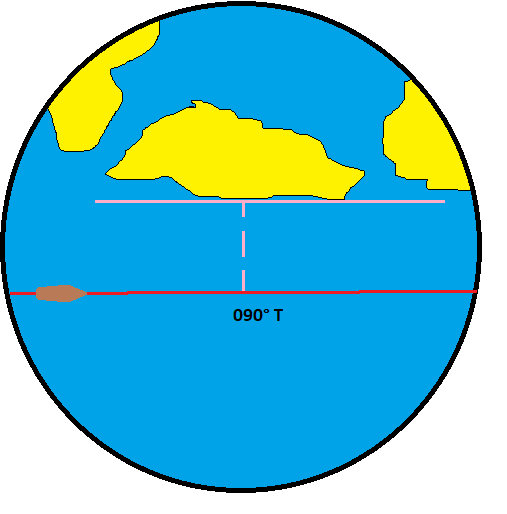
The vessel is shown to be maintaining the required track, with the target (point of land) . The ship is following a ground track of 090°T.

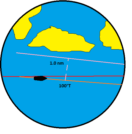
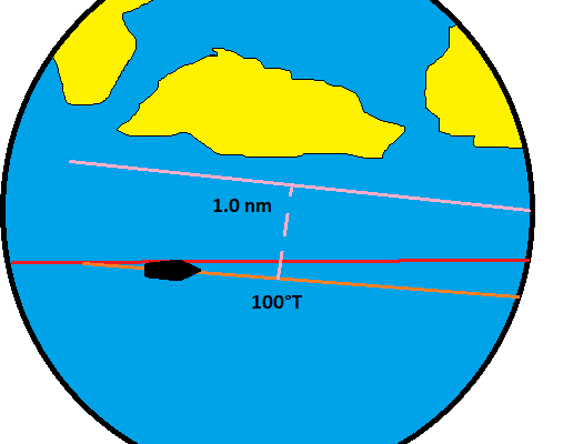
The ship is shown to be setting away from the shore. The point of land is moving outside the PI Line. The ship is following a ground track of 100°T.

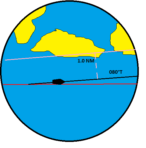
The ship is shown setting towards the shore. The point of land is moving inside the PI line. The ship is following a ground track of 080°T.

Navigation Tags:parallel indexing, radar parallel indexing

Post navigation

Previous Post: Azimuth Mirror
Next Post: Purpose of Annex V

Leave a Reply Cancel reply

Your email address will not be published. Required fields are marked *

Categories

  • Bulk Carrier
  • Cargo handling
  • Engine Room Operations
  • LSA & FFA
  • Maritime Industry
  • Maritime Law
  • Merchant Shipping
  • Navigation
  • Rules and Regulation
  • Ship Construction
  • Shipboard operation
  • Stability
  • Tanker
  • Uncategorized

Blog is primarily for candidates appearing for certificate of competency exams but such is the detail that while being equally suitable for the beginner, it is also reference work for experienced seaman, and the layout and style of blog make it suitable for shipboard training where practical experience can be allied to the theoretical approach.

Recent Comments

  • capt on Radar Best Practice -ARPA
  • admin on Dry Docking (Theory & Numericals)
  • Stelios Karamplakas on Dry Docking (Theory & Numericals)
  • Farid OMARI on Demurrage
  • admin on Tanker Cargo Calculations

Copyright © 2018 knowledge of sea – All Rights Reserved.

If you’re unsure about what type of training will work best for you, just tell us a little more about your needs. We will get back to you as soon as possible with the answers you need!

All answers will be from sailor mouth, who is practically working on board.

January 2026
S M T W T F S
 123
45678910
11121314151617
18192021222324
25262728293031
« Dec    

Copyright © 2026 Knowledge Of Sea.

Powered by PressBook WordPress theme

Go to mobile version